


|
||

|

|
|

|
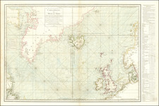
Illustrating the Gulf Stream and Scarce sea chart of the North Atlantic, published by the French Depot De La Marine in 1854.
The map shows magnetic declinations and a number of other observations.
Of note are the red lines and pencil notes, showing 2 voyages of a French ship which touched on the Spanish coast near Vigo and may have entered the Mediterranean, but whose primary route led through the Canary islands to the coast of Africa, with extensive notes on travel between Cap Vert, Senegal and the Cap Vert Islands, tracked by date.
A name appears in the top right margin, P. de Longeville.
The Dépôt de la Marine, known more formally as the Dépôt des cartes et plans de la Marine, was the central charting institution of France. The centralization of hydrography in France began in earnest when Jean-Baptiste Colbert became First Minister of France in 1661. Under his watch, the first Royal School of Hydrography began operating, as did the first survey of France’s coasts (1670-1689). In 1680, Colbert consolidated various collections of charts and memoirs into a single assemblage, forming the core of sources for what would become the Dépôt.
The Dépôt itself began as the central deposit of charts for the French Navy. In 1720, the Navy consolidated its collection with those government materials covering the colonies, creating a single large repository of navigation. By 1737, the Dépôt was creating its own original charts and, from 1750, they participated in scientific expeditions to determine the accurate calculation of longitude.
In 1773, the Dépôt received a monopoly over the composition, production, and distribution of navigational materials, solidifying their place as the main producer of geographic knowledge in France. Dépôt-approved charts were distributed to official warehouses in port cities and sold by authorized merchants. The charts were of the highest quality, as many of France’s premier mapmakers worked at the Dépôt in the eighteenth century, including Philippe Bauche, Jacques-Nicolas Bellin, Rigobert Bonne, Jean Nicolas Buache, and Charles-François Beautemps-Beaupré.
The Dépôt continued to operate until 1886, when it became the Naval Hydrographic Service. In 1971, it changed names again, this time to the Naval and Oceanographic Service (SHOM). Although its name has changed, its purpose is largely the same, to provide high quality cartographic and scientific information to the France’s Navy and merchant marine.
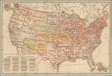

![[Map of the United States, illustrating the routes of the Canadian Pacific Railway and the Seattle, Lake Shore and Eastern Railway]](https://storage.googleapis.com/raremaps/img/small/71080.jpg)
![Charte von Den Vereinigten Staaten von Nord-America nebst Louisiana . . . 1805 [Rare 1st State of Gussefeld's Louisiana Purchase Map]](https://storage.googleapis.com/raremaps/img/small/63496.jpg)