|
||

|

|
|

|
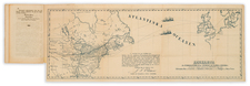
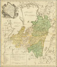
Stock# 70219
Description
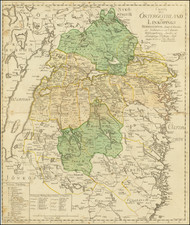
Detailed engraved map of Skaraborg, published in Sweden by Nils Marelius in 1780.
The map depicts the area between the lakes Vanern and Vattern.
The regional subdivisions, towns, and roads of the area are shown.
The map was engraved by C. Bergquist, who signed the plate along the bottom of the image.
Condition Description
Original hand-color. Trimmed to the neatline along the left edge.
Nils Marelius Biography
Marelius is considered Sweden's foremost cartographer before the 19th century,
Nils Marelius first worked at the the Swedish Surveying and Mapping Office in 1734. He became an assistant surveyor in 1747 and later an engineer, working his way up to director in 1781.
Marelius authored and nd published a number of important maps and cartographic surveys.
Marelius became a member of the Academy of Sciences in 1769.
![[ Baltic Sea / Sweden / Poland / Rugen ] De Custen van Denemarcken en Sweden, van Valsterbon tot Schenkenes, als mede de cust vanten van Pomeren van't eylant Rugen tot Rygshooft . . .](https://storage.googleapis.com/raremaps/img/small/99944.jpg)