


|
||

|

|
|

|
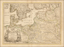
Fine old color example of this scarce map of Lithuania, Latvia, Estonia and the Eastern part of Poland, published in Amsterdam by Frederick De Wit.
Oriented with west at the top, the map also includes a large portion of modern day Belarus and northern Ukraine.
The map is quite scarce on the market. We note no examples listed in AMPC in the past 19 years.
De Wit (1629 ca.-1706) was a mapmaker and mapseller who was born in Gouda but who worked and died in Amsterdam. He moved to the city in 1648, where he opened a printing operation under the name of The Three Crabs; later, he changed the name of his shop to The White Chart. From the 1660s onward, he published atlases with a variety of maps; he is best known for these atlases and his Dutch town maps. After Frederik’s death in 1706, his wife Maria ran the shop for four years before selling it. Their son, Franciscus, was a stockfish merchant and had no interest in the map shop. At the auction to liquidate the de Wit stock, most of the plates went to Pieter Mortier, whose firm eventually became Covens & Mortier, one of the biggest cartography houses of the eighteenth century.

![[Heightened in Gold!] Pas-Caart van de Oost Zee Verthoonende Alle de ghelgentheydt tusschen 't Eylandt Rugen ende Wyborg. Op nieuws oversien en verbeetert. . . 1665](https://storage.googleapis.com/raremaps/img/small/83731.jpg)
![[ Marshal Oudinot Copy ] Landes-Grenze zwischen dem Königreich Preussen und dem Herzogthum Warschau nach der am 10ten November 1807, dem Tilsiter Friedens Tractat vom 9ten Juli 1807 gemäss, zu Elbing abgeschlossenen Convention und der im Jahre 1808 darauf erfolgten örtlichen Begrenzung, als Supplement, der von Schröttersche](https://storage.googleapis.com/raremaps/img/small/99041.jpg)
![[ Gdansk Environs ] Schweetsche Schans Auff Den Weyselstrom ongefehr neun Meilen von Dantzig gelegen Ao. 1626.](https://storage.googleapis.com/raremaps/img/small/68842.jpg)