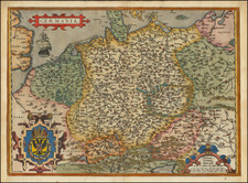
|
||

|

|
|

|
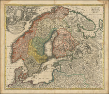
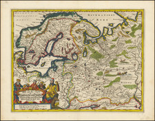
Striking full-color, gold-heightened example of Goos' general chart of the Baltic Sea. The map extends from the coasts of Finland to Scandinavia, Latvia, Lithuania, Estonia, Poland, and Denmark. This map was originally published by Pieter Goos in Amsterdam in 1669 as part of an atlas of global sea charts.
The map is striking for its simple yet beautiful nature. It includes a wealth of sea-faring information, with depth soundings and the locations of shoals shown. The names of various regions are provided, and coastal towns are named. Decorative ornaments include seafaring vessels and various compass roses. The magnificent coats of arms of Sweden can be found in the upper left.
Pieter Goos (ca. 1616-1675) was a Dutch map and chart maker, whose father, Abraham Goos (approx. 1590-1643), had already published numerous globes, land and sea maps together with Jodocus Hondius and Johannes Janssonius in Antwerp. Pieter gained recognition due to the publication of sea charts. He bought the copperplates of the famous guide book for sailors, De Lichtende Columne ofte Zeespiegel (Amsterdam 1644, 1649, 1650), from Anthonie Jacobsz. Goos published his own editions of this work in various languages, while adding his own maps. In 1666, he published his De Zee-Atlas ofte Water-Wereld, which is considered one of the best sea atlases of its time. Goos' sea charts came to dominate the Dutch market until the 1670s, when the Van Keulen family came to prominence.