


|
||

|

|
|

|
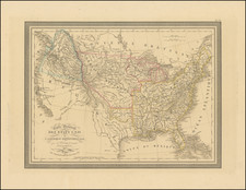
Fascinating educational map of the United States, bearing the engraver's signature of Neele, Strand (London).
The map presents a remarkable look at the United States at about the time Lewis & Clark set out on their expedition.
The map follows the cartographic features of Arrowsmith's maps of 1802, and most notably the numerous tentative water routes which are shown as possible tributaries of the Upper Missouri River, draining directly from the single cordillera depiction of the Rocky Mountains.
The map includes at least 3 symbols which are apparently intended as prompt for students to add the names of cities, Indian Tribes and major major cities.
The map appeared in A general and classical atlas: accompanied with a concise treatise on the principles of geography; and with a few practical remarks on the application of maps to the purpose of instruction. By the Rev. Edward Patteson, M.A. of Richmond, Surrey. Printed for the author, by G.A. Wall, Richmond: and sold, in London by Messrs. Rivington, St. Paul's Church-Yard; Mr. Faden (et al.) ... 1804.
![Die Vereinigten Staaten von Nord Amerika (Ostlicher Theil) [New York City Inset]](https://storage.googleapis.com/raremaps/img/small/62359.jpg)
![[ English Plantations in North America ] A New Map of the most Considerable Plantations of the English In America Dedicated to His Highness William Duke of Glocester.](https://storage.googleapis.com/raremaps/img/small/98233.jpg)
![United States Atlas [rolled]](https://storage.googleapis.com/raremaps/img/small/91367.jpg)