


|
||

|

|
|

|
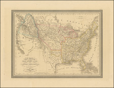
This remarkable map, published in the April 5, 1917 issue as a supplement to Motor Age, captures a transformative era in American transportation. Comprising a vivid tapestry of early 20th-century highways, it highlights the nation's burgeoning motorway system and those routes deemed significant for military purposes.
Laid out on a scale that allows for detailed scrutiny of key roadways and regions, the map encompasses the contiguous United States, bordered to the north by parts of Canada. The overall composition is elegantly balanced with the natural contours of North America's vast landscape. Topographic details such as mountains, valleys, rivers, and coastal lines are meticulously delineated, providing a rich geographical context.
A distinctive feature is the color-coded categorization, which emphasizes major scenic and historical areas, lakes and rivers, arid regions based on annual rainfall, deserts, national parks, and national monuments. These classifications offer a snapshot of natural and cultural landmarks of the time and indicate areas of potential strategic importance.
To assist the contemporary traveler, the map incorporates a comprehensive legend, detailing the abbreviations used for America's main highways. From the Arrowhead Trail (A.H.T.) to the Yellowstone Trail (Y.T.), these abbreviations reflect a fascinating array of named routes, many of which have evolved or been subsumed into today's modern interstates.
Additionally, "America's Tour Grounds" are enumerated, guiding the traveler's attention to scenic spots ranging from the "Mountains and Lakes of New England" to the "Mission Territory and Southern California."
Published by Motor Age at 5 South Wabash Avenue, Chicago, and copyrighted in 1917, the map offers a glimpse into a world where the automobile was rapidly revolutionizing travel, reshaping commerce, and influencing military strategy. The use of reserved colors and detailed typography underscores the map's dual purpose: to be both functional for the traveler and informative for the military strategist.
Strangely, according to the map, there were only two deserts in America; one north of Barstow, California, and one west of the Great Salt Lake.
![Colton's United States Shewing Military Stations, Forts &c. . . . 1861 [Shows Colorada!]](https://storage.googleapis.com/raremaps/img/small/95088.jpg)