


|
||

|

|
|

|
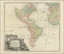
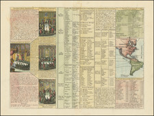
A nice example of the Homanns' second map of America, which reflects the substantial new information obtained since the issuance of the Johann Baptiste Homann's first map of America. The decorative cartouche uses some very lively visual imagery, including volcanoes and a nice allegorical scene representing the people, flora, and fauna of America.
The interior of North America benefits from the knowledge obtained from the Jesuits along the Mississippi River and from the English and Dutch information along the coast. The French are still the dominant force in North America the Spanish in South America, though the imminent French and Indian War will change this. The Great Lakes are only starting to be accurately charted by D'Anville and later Mitchell. The west coast conforms to the French updates provided by De L'Isle and progeny. South America is substantially corrected from earlier models.
The Northwest Coast of America and Northwest Passage are still unknown but wishfully shown. Quivira, the legendary land of gold and silver, is shown considerably east of its normal location. Francisco de Coronado began his search for Quivira in 1541, but found only Indian villages. He did however report to the Spanish King that the land was suitable for growing all of the products of Spain. Quivira migrated progressively further north and east, until it disappeared from maps in the late 18th Century. The present map seems to be influenced primarily by the highly important map of America by De L'Isle first issued in 1700, although the Haas retains some of the great mythical cartographic features in the interior regions.
The map was likely bound into Homann's Atlas Scholasticus, one of the most popular and widely distributed atlases of the second half of the 18th century, which would continue to be issued with periodic changes to the maps for over 50 years.
Homann Heirs was a German publishing firm that enjoyed a major place in the European map market throughout the eighteenth century. Founded in 1702 by Johann Baptist Homann, the business passed to his son, Christoph, upon Johann’s death in 1724. Christoph died in 1730, aged only 27, and the firm was inherited by subsequent Homann heirs. This altered the name of the company, which was known as Homann Erben, or Homann heirs. The firm continued in business until 1848.
![[Portrait] L'Amerique.](https://storage.googleapis.com/raremaps/img/small/79745.jpg)
![[ Separately Published with Early Hand Drawn Addition of the Le Maire Strait ] Americae Sive Novi Orbis Nova Descriptio](https://storage.googleapis.com/raremaps/img/small/94478.jpg)