![Ireland in Provinces and Counties [with] County Map of Scotland By Samuel Augustus Mitchell Jr.](https://storage.googleapis.com/raremaps/img/small/78014.jpg)


|
||

|

|
|

|
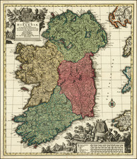
A decorative map with Ireland and Scotland side by side, colored by counties. Includes a decorative border. Nice detail in both maps, including early roads, towns, railroads, rivers, lakes, islands, etc. Inset of the Shetland Islands.
Mitchell makes an interesting choice in portraying the two countries together. Perhaps he chose to do so as these two countries are linked in Celtic heritage as well as producing a lot of American immigrants. Alternatively, this could be the representation of the two subservient, non-Anglo-Saxon European components to the United Kingdom.
Samuel Augustus Mitchell Jr. inherited the Mitchell Company from his father in 1860. For over thirty years, the company had specialized in the production of school atlases and wall maps of America. They were one of the pioneers on engraving on steel plates. In 1860, Samuel Jr. released the New General Atlas, which had been compiled in house and replaced a previous atlas by Tanner. The elder Mitchell died in 1868 and Samuel Jr. continued the business until the 1890s. At its height, the Mitchell Company employed 250 people and sold 400,000 publications annually.
![[Siege of Dunboy] Bere Island](https://storage.googleapis.com/raremaps/img/small/83706.jpg)
![[Scotland] Scotiae Tabula](https://storage.googleapis.com/raremaps/img/small/35612.jpg)