|
||

|

|
|

|
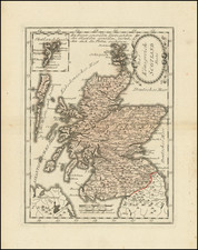
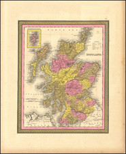
Striking and highly detailed map of Scotland in two sheets.
Scotland in the 1830s was a land in transition. With its rugged landscapes and sweeping valleys, this nation was witnessing the early influences of the Industrial Revolution, most notably through the expansion of its railway system.
The map from this period showcases the natural wonders of Scotland. One could trace the Grampian Mountains, with Ben Nevis standing tall, and follow the winding pathways of rivers such as the Clyde, Tay, and Spey. These natural landmarks have always defined Scotland's terrain, offering both beauty and challenges to its inhabitants.
But the real markers of change on this 1830 map were the emerging lines of the railways. By this time, several railroad initiatives had been established. The Garnkirk and Glasgow Railway, opened in 1831, was primarily designed for coal transport. Another notable line was the Edinburgh and Dalkeith Railway, which started in 1831 with horse-drawn carts but soon welcomed steam-powered travel. The Dundee and Newtyle Railway, established in 1832, showcased innovative engineering with its inclined planes and tunnels.
These railroads, though few at the time, signaled the beginning of a transport revolution that would dramatically change the nation's landscape, economy, and daily life. Cities and towns connected by these railways, such as Glasgow, Edinburgh, and Dundee, were evolving into major industrial and commercial centers.
While the railway's promise of progress was evident on the map, so too were the timeless features of Scotland's towns and landmarks. Edinburgh, with its iconic castle, was prominently marked, representing its significance both historically and politically. Glasgow's positioning by the River Clyde highlighted its burgeoning industrial prominence. Other significant towns, like Aberdeen to the northeast and Inverness in the Highlands, were also clearly marked, each telling its own tale of Scotland's rich history and cultural tapestry.
The Lizars were a Scottish family of engravers and printers who produced many views and maps. Daniel Lizars Sr. (1754-1812) was the son of a shoemaker, but he apprenticed with Andrew Bell, a printer and engraver. Lizars set up his own printworks near St. Giles Cathedral and took on his own apprentices, including George Bartholomew, whose son John would go on to found the important mapmaking firm later know as John Bartholomew & Son Ltd.
Daniel Sr. had three sons: Daniel Jr., John, and William Home. He also had a daughter, Jane Home. Daniel Jr. (1793-1875), the youngest of the boys, apprenticed in his father’s shop alongside George Bartholomew. When his father died in 1812, Daniel Jr. took over much of the business, expanding it and specializing in maps. The company went bankrupt in 1832, however, and Daniel emigrated to Canada.
John Lizars (1792-1860), the middle son, studied medicine and became Professor of Surgery at the Royal College of Surgeons of Edinburgh, as well as senior surgeon at the Royal Infirmary of Edinburgh.
William Home Lizars (1788-1859), the eldest, also apprenticed in his father’s shop. After learning engraving, William entered the Trustees’ Academy to learn under John Graham. He was a skilled painter and artist. When his father died, and after his Daniel Jr. left, he carried on printing and invented a method of etching that looks like wood engraving.
![[ British Isles ] (Tabula. I. Europae)](https://storage.googleapis.com/raremaps/img/small/72090.jpg)