|
||

|

|
|

|
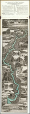
Promoting Emigration and Selling Land on the North Island -- Made for the New Zealand Company
Fine, rare map of the Manawatu and Horowhenua Districts in the Manawatū-Whanganui region of the North Island, published for the New Zealand Company, one of the early, and controversial, entities dedicated to the settlement of New Zealand by British colonists. This is the first detailed map of the region.
The map shows the area between Lake Horowhenua and the Manawatu River, on the west coast of the North Island. To the east are lightly-drawn hills, while the coast is dominated by sand dunes.
The land is portioned into “country sections” of 100 acres each. These would be advertised and sold to prospective landlords in England, who were then supposed to immigrate to be New Zealand’s new landed gentry. The Company would pay for laborers to emigrate to work the land. In practice, however, the landlords tended to stay in England, while the laborers came in great numbers, creating an uneven system.
The map is simply drawn, suggesting an open and easily-accessible land. The coat of arms, with a British man and a Maori man flanking the symbolic arms, is above the modestly-drawn title. Below is a scale and a note of the publisher, which was Smith, Elder, and Co. of Cornhill. They published all the books, maps, and pamphlets of the New Zealand Company, which were printed at a rapid rate in the early 1840s.
Interestingly, a note in the lower left explains that this map was engraved with the Omnigraph. The Omnigraph was only patented in 1842 by Becker, who engraved this plate. The invention was a new method of engraving on steel renowned for clarity of line and its cheap price as compared to other methods.
As noted by the initial New Zealand Company surveyors of 1840, this area’s land was rich and highly suitable for agriculture. The notes on this plan also reflect this, with effusive notes such as, “The whole of this is an excellent Soil” and “Beautiful undulating land.” In Manawatu, some of the sections were in a “Large Marshy Flat,” or swamp, but this was “easily drained” according to a settlement guide of 1848.
This guide explains that, by 1848, 329 of the districts’ country sections had been selected. The guide goes on to describe the course of the Manawatu River, seen on this map:
The course of the Manawatu is exceedingly tortuous; so much so, that the natives have a legend that is was formed by an Atua, or “Evil Spirit,” who was in the form of a large Totara-tree, and wormed himself along like an eel on his way from the east coast to Cook’s Strait. His name was Okatia…One point on the banks of the Manawatu, thirty-six miles by the winding of the river, is only eight in a straight line from the sea.
However, as the notes to the right show, the land was far from uninhabited. Green-shaded sections were the potato gardens of the Maori peoples of the area, while the yellow sections are “native reserves.” In reality, the Maori used and lived on more of the land than is shown here, as evidenced by the Maori place names scattered among the sections.
The New Zealand Company
The New Zealand Company was established in 1839 to colonize New Zealand. They were not the only such company, but they were the most prominent. For example, the New Plymouth Company, established in 1840 to settle a peninsula to the north of these districts, merged with the New Zealand Company in April 1841.
The roots of the company go back further. The British first settled permanently on New Zealand when missionary activity began there under the auspices of the Church Missionary Society. Samuel Marsden, William Hall, Thomas Kendall, and John King were the first missionaries; Marsden gave the first sermon in New Zealand on Christmas Day 1814.
By 1831, there were enough European settlers to cause considerable consternation on the part of the Maori leaders. Thirteen Northern chiefs petitioned King William IV for protection, which the Crown granted. Two years later, the British Resident, a consular position, arrived and built a house in Waitangi. In 1835, the Resident, James Busby, drafted He Wakaputanga o te Rangatiratanga o Nu Tirene, the Declaration of Independence of New Zealand, which placed the sovereign power of the land with the Maori and their hereditary chiefs. By 1839, 52 chiefs had signed the declaration.
In the meantime, the British, who had not sanctioned the declaration, decided to begin formally colonizing New Zealand in 1837, the same year discussions began to form the New Zealand Company from a previous venture, the New Zealand Association, which failed to gain a royal charter. The British government appointed William Hobson to serve as Consul, under the authority of the Governor of New South Wales. Hobson was to oversee the purchase of land from the Maori.
By 1840, there were roughly 2,000 Europeans living in New Zealand, the majority single men—whalers, traders, and missionaries—and 7 of 10 of them were of British descent. They usually arrived via Sydney, in New South Wales.
At the same time the government was appointing a Consul, the first New Zealand Company ship had set sail for the islands. The Tory was to survey and buy land for a settlement, which was decided to be at Port Nicholson (now Wellington Harbour). The first settlers arrived in Port Nicholson in January 1840, having been attracted as laborers by exaggerated pamphlets and propaganda published by the Company.
Later in 1840 a group of surveyors of the New Zealand Company left Wellington and went up the west coast of the North Island. They mapped all the way as far as present-day New Plymouth, including the districts seen here. The original report of this survey is in the Public Records Office, Kew, London, but the map which is supposed to have accompanied the report is now lost. This expedition was the first time any Europeans had explored by land along the west coast.
The Treaty of Waitangi and the downfall of the New Zealand Company
The New Zealand Company was based on the idea that only civilized (white) men should own land; they sold land in “country sections”, as seen here, at “suitable prices” to investors. Then, the Company shipped over laborers to ensure there was a labor pool to work the land. However, many of the owners never emigrated, making them absentee landlords. Additionally, many of the purchases of land from the Maori were dubious at best, including in the area shown here.
Ironically, just as the initial settlers in Port Nicholson and the Company’s others early settlements—Whanganui (September 1840), New Plymouth (November 1841), and Nelson (February 1842)—were realizing that New Zealand was not the paradise they had been promised and that the land had not been fairly purchased, news of the New Zealand Company’s royal charter, granted in 1841, reached the islands. This was not enough to quell the discontent of the settlers and debate swirled in London as to the reputation of the Company.
In New Zealand, 1840 also marked the signing of the Treaty of Waitangi. The New Zealand Company was not the only body engaged in dubious land deals with the Maori. Governor Gipps of New South Wales prohibited further land sales early in the year, calling for all existing purchases to be reviewed. On February 6, 1840, the Treaty of Waitangi was signed by roughly forty chiefs; by September five hundred more signed on. A draft of the treaty had been read in Maori the day before, but the degree to which it contents were fairly translated and understood before being signed is a matter of controversy to this day.
The Treaty ceded the lands of New Zealand to British control and began the systematic territorial and material dispossession of the Maori. One of the reasons for this move by the Crown was to counter New Zealand Company attempts to declare sovereignty over the Cook Straits, which was south of the main British strongholds on the North Island.
As this plan shows, the New Zealand Company continued to sell land after the Treaty, on the North and the South Islands. New Zealand Company settlers clashed with the Maori over a shady land deal in the Wairu Incident of 1843; six Maori and 22 Europeans were killed. The fortunes of the New Zealand Company declined even as this map was published and the company surrendered its charter in 1850; it officially dissolved in 1858.
Despite its short-lived and controversial history, the New Zealand Company was responsible for bringing 14,000 of the 18,000 people who settled in New Zealand between 1840 and 1851. Their promotional practices were used to continue to draw European settlers to the islands even after the company folded.
Rarity
This map is very rare. OCLC locates one example of the map at the British Library. There are also three examples in the Alexander Turnbull Cartographic Collection of the National Library of New Zealand and what appears to be a reduced-size reproduction in the library of the Hockens Collection of the University of Otago.
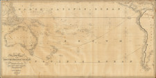
![A Chart of the South Sea [1st English Map of the Pacific Ocean]](https://storage.googleapis.com/raremaps/img/small/47376.jpg)