|
||

|

|
|

|
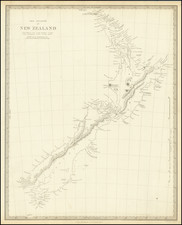
The First Decorative Map of New Zealand -- Drawn From Cook's Official Account
Nice hand-colored example of Zatta's map of New Zealand, one of the most decorative and highly sought after editions of Cook's mapping of New Zealand and one of the largest format presentations of Cook's map.
Antonio Zatta's map of New Zealand offers an insightful view into the cartographic representations of the 18th century. Published in Venice, Italy, Zatta's map is an artful distillation of Captain James Cook's comprehensive voyages around the islands. Its hand-colored nature and intriguing details make it a key part of the historical puzzle that depicts New Zealand's exploration by Europeans.
The map effectively delineates New Zealand into two islands, separately acknowledging the Southern Island—a clear progression from the singular landmass first charted by Dutch explorer Abel Tasman in 1642. The route that Cook undertook around the islands, as well as his astronomical observations, are prominently displayed. This feature is a testament to Cook's meticulous and thorough approach to exploration, where he spent six months sailing along the coast of New Zealand.
The legacy of Cook's exploration can be traced through the varied place names that adorn Zatta's map. A mixture of European and native Maori nomenclatures offer a snapshot of the cultural interplay at the time. Cook's visit to the Bay of Islands on November 29, 1769, for example, is marked, as is Poverty Bay, where the Endeavour first anchored on October 8, 1769. Ship Cove, a favorite anchorage of Cook during his subsequent visits, also graces the map. The native place names reflect the rich oral history and geographical knowledge of the indigenous Maori people, providing another layer of depth to Zatta's representation.
The map features a series of annotations—narrative cues that add to the viewer's understanding of the land and the nature of Cook's expedition. Through these notes, Zatta demonstrates his thorough reading of Cook's official account, successfully integrating Cook's first-hand experiences into the geographic layout.
Perhaps the most eye-catching feature of Zatta's map is the decorative cartouche, which depicts a native village scene. This inclusion provides a glimpse into the indigenous lifestyle and societal organization during the 18th century. While aesthetically pleasing, the cartouche serves as a reminder that New Zealand had a rich cultural history long before European explorers set foot on its shores.
Overall, Antonio Zatta's map of New Zealand not only satisfies the viewer with its pleasing aesthetics and hand-colored charm, but it also provides an intriguing glance into the historical, cultural, and exploratory facets of the 18th century. Through the clear delineation of Cook's exploratory routes and the thoughtful inclusion of native and European place names, the map serves as a rich testament to New Zealand's storied past.
Antonio Zatta (fl. 1757-1797) was a prominent Italian editor, cartographer, and publisher. Little is known about his life beyond his many surviving published works. It is possible that he was born as early as 1722 and lived as late as 1804. He lived in Venice and his work flourished between 1757 and 1797. He is best known for his atlas, Atlante Novissimo (1779-1785), and for his prolific output of prints and books that were both precisely made and aesthetically pleasing. Zatta clearly had a large network from which to draw information; this is how he was able to publish the first glimpse of the islands visited by Captain Cook in the Atlante Novissimo. Zatta also published books of plays and architecture.
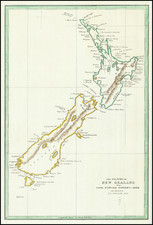
![[ New Zealand ] To the Right Honourable The Secretary of State for the Colonies &c. &c. &c. This Chart of New Zealand, from Original Surveys . . . Third Edition . . .](https://storage.googleapis.com/raremaps/img/small/70538.jpg)