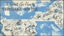
|
||

|

|
|

|
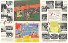
Unique pictorial map from the dawn of the American airline industry, showing, for almost the first time, a cross-country network of passenger and mail air routes.
The map was made by Richard F. Lufkin "General Draftsman - Boston", on behalf of the Civic Bureau of the Boston Chamber of Commerce, probably to commemorate the inauguration of regular passenger service to Boston on April 15, 1929.
The construction of the map is rather unusual; a base map has been printed with a blueprint method, then Lufkin has gone over the printed map by hand, adding and changing details in red and white ink. This was clearly part of a process to build up the base image and eventually reproduce the map with a photomechanical method. Although the intention was probably to print the map, we have been unable to find any other examples of this map in either a manuscript or printed form.
Lufkin probably derived his information from USPS air mail maps and other similar sources. The first Post Office airmail route was established as a proof-of-concept in 1918, running between New York City, Philadelphia, and Washington D.C. The USPS provides an informative collection of early maps of the airmail routes on their website. That essay includes the following summary of early cross-country airmail operations:
A 2,680-mile long transcontinental airmail route linking New York with San Francisco was completed in 1920. Initially, mail was flown by day and carried on trains at night. One coast-to-coast trip took about 3 ½ days, which was nearly a day quicker than the all-rail time. Regular service with night flying began in 1924, reducing the trip to about 33 hours. Airmail routes from Seattle to Victoria, British Columbia, and from New Orleans to Pilottown, Louisana, were foreign airmail routes, operated under contract — they expedited mail delivery to foreign-bound steamship.
Some of the choices of where and how to incorporate a city into the national network seem rather strange from a modern perspective. Towns such as Ponca City, OK; Pilottown, LA; Douglas, AZ; Elko, NV; or Whapeton, ND are not obvious choices as early stops in the national air network. That being said, in many cases, there are discernable reasons for these inclusions. For instance, in the case of Pilottown, Louisiana, as mentioned in the preceding paragraph, it was an exchange point for mail coming off foreign steamships that were not necessarily going to New Orleans. Ponca City and Douglas were probably required stopovers when airplane technology required shorter legs for long journeys.
The title cartouche includes the line "Some mail routes now carry passengers and all routes may carry them in the near future."
![[ Wines of Italy ] Vini D'Italia](https://storage.googleapis.com/raremaps/img/small/104047.jpg)