|
||

|

|
|

|
Nice example of Seutter's decorative adaptation of De L'Isle's important map of 1703.
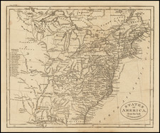
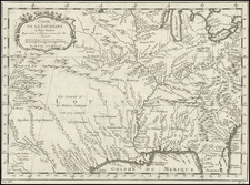
The map provides a view of North America from the Great Lakes through the West Indies. The British colonies are confined east of the Appalachian Mountains, France controls the Mississippi valley and Florida, and Spain possesses Mexico and New Mexico. Political divisions as dictated by the Treaty of Utrecht in 1713. While geographically nearly identical to Delisle's chart, this map is very decorative with the lower-left corner filled with a huge sea battle and the Atlantic filled with four inset plans of Panama, Havana, Carthagena and Vera Cruz.
The details of the Mississippi Valley were the most radical departure from earlier maps, accurately depicting the information provided by the French Jesuits in North America in the late 17th Century. Nice detail along the Rio Grande and in Texas.
Matthäus Seutter (1678-1757) was a prominent German mapmaker in the mid-eighteenth century. Initially apprenticed to a brewer, he trained as an engraver under Johann Baptist Homann in Nuremburg before setting up shop in his native Augsburg. In 1727 he was granted the title Imperial Geographer. His most famous work is Atlas Novus Sive Tabulae Geographicae, published in two volumes ca. 1730, although the majority of his maps are based on earlier work by other cartographers like the Homanns, Delisles, and de Fer.
Alternative spellings: Matthias Seutter, Mathaus Seutter, Matthaeus Seutter, Mattheus Seutter
![[ Pictish Man Holding Severed Head ] Picti icon](https://storage.googleapis.com/raremaps/img/small/99837.jpg)