|
||

|

|
|

|
Folio. Recent boards. 7 engraved maps (of 8)
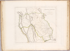
A very rare atlas of the Seven Year's War and the French and Indian War. With 7 double-page maps colored in outline, including map of the eastern coast of North America (based on Bellin) with the conflicting territorial claims of the British and French.
Extremely rare special atlas on the history of the Seven Years' War and the Anglo-French Colonial War. With maps of North America (east coast with the Great Lakes between New Orleans and Newfoundland), the Polish Baltic coast (with Rügen / Usedom to Memel), Silesia, Bohemia, Moravia, northern Germany and Lower Saxony. The cards were engraved by the Italian scientist, historian and writer Francesco Griselini (also Grisellini; 1717-1783), probably mostly based on his own designs (Lower Saxony according to P. Antegnati). "The number of G.'s works in the most varied areas of knowledge is very large ... In his youth G. was drawing maps and plans, and samples of his dexterity are still available in several works" (W.). - Title slightly browned, a little stained and streaked at the bottom, card margins in places slightly finger-stained, few small. Marginal lesions deposited; America map also with 3 wormholes in the picture and in the w. Margins with small Corner repair and small closed edge tear. Bohemia with small Rust stain in the w. Edge. The title mentions 7 cards, but after a comparative copy, another card is missing ("Il corso del Reno").
![Atlas Juvenilis, eller Geographiska Chartor till Ungdomens tienst i metodisk ordning författade af Andr: Åkerman, Graveur wid Kongl. Wet. Soc. i Uppsala. [Youth Atlas, or Geographical Maps for the Service of Youth in Systematic Order Composed by Andr. Åkerman, Engraver at the Royal Scientific Society in Uppsala.]](https://storage.googleapis.com/raremaps/img/small/101834.jpg)
![[Seattle's First Zoning Ordinance] Zoning Ordinance of the City of Seattle Effective July 27, 1923](https://storage.googleapis.com/raremaps/img/small/69390.jpg)
![(Cassini Moon Map) Atlas Céleste de Flamstéed, approuve par l'Académie Royale des Sciences, et publié sous le privilege de cette compagnie [with:] Reduction de la Grande Carte de la Lune de J. Dom. Cassini](https://storage.googleapis.com/raremaps/img/small/79182.jpg)