|
||

|

|
|

|
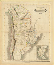
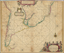
Scarce map of Gran Chaco, published in Buenos Aires in 1894.
The map is the first scientifically accurate cadastral survey of the Gran Chaco region of Northern Argentina, which includes significant information regarding recent settlement activities.
The map is based upon the work of Uruguayan surveyor Melitón González, and published in Buenos Aires in 1894 during a critical period in the area’s early development. The finely chromolithographed map depicts the recently incorporated territories of Chaco and Formosa, featuring the locations of towns, forts and outposts, as well as numbered settlement sections and departmental and territorial boundaries. Of particular interest are the numerous cadastral lots owned by named individual proprietors and land development companies. This information reveals the demographically diverse nature of the settlements, including names of Spanish, Italian, Jewish, British and German origins, amongst others. It is thus one of the seminal historical documents relating to Northern Argentina.
The Development of the Argentinian Gran Chaco
The Argentinian part of the Gran Chaco was historically a sparsely populated region, originally home to the Pilagás, Wichis and Tobas native peoples, and from the late 16th Century the site of a few isolated Jesuit missions and European trading posts. Before modern farming techniques, broad-based development of the region was considered nearly impossible due to the arid conditions, indifferent soil and complex relations with the native peoples. During much of the 19th Century, settlement was further hindered by the fact that the region was actively disputed between Argentina and Paraguay.
Argentina and her allies annihilated Paraguay during the War of the Triple Alliance (1865-70), with Argentina being awarded all of the land south of the Pilcomayo River. In 1872, Argentina formed its enlarged domains in the region into the Gran Chaco Territory, and opened the area for development. Many settlement schemes, or ‘colonias’ were established, while the city of Resistencia was founded at the site of the fort of San Fernando in 1876, and the city of Formosa was established in 1879. A diverse array of immigrants flooded into the region from Europe, in addition to experienced ranchers from the Pampas, bringing with them knowledge of advanced agrarian techniques that made the Gran Chaco economically viable. In 1884, the territory was divided along the Bermejo River into the separate territories of Chaco and Formosa.
Until the mid-1880s, the mapping of the region was of variable quality, as while some fine cadastral surveys of specific grants were made, there were no general maps of any decent quality. This was causing great confusion with the awarding of land grants and the creation of infrastructure.
To remedy the situation, the Argentine government commissioned Melitón González, an Uruguayan surveyor and development planner, to create the first scientific cadastral map of the Argentinian Gran Chaco. Commensurate with his surveys, González wrote a book on the region, El Gran Chaco Argentino (Buenos Aires, 1890). This was followed, in 1894, by the separate publication of the present map, finely chromolithographed by the leading Buenos Aires firm of Jacob Peuser. Some copies of El Gran Chaco Argentino that were issued after this time had examples of the map bound in, although the separately issued edition of the map remains very rare.
González’s map of the Argentinian Gran Chaco was viewed by both government and commercial concerns to be critically useful in guiding settlement and infrastructure programs in the region, and remained the base map of the area for many years.
Rarity
The map is very rare on the market.