This item has been sold, but you can enter your email address to be notified if another example becomes available.


|
||

|

|
|

|
Stock# 60026
Description
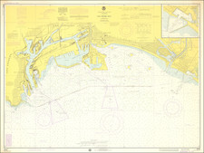
Fine 19th Century Sea Chart of Santa Monica Bay
Detailed 4 sheet map of Santa Monica Bay, illustrating a report considering the feasibility of locating a deep water harbor in Santa Monica Bay, conducted by the Army Corps of Engineers in 1890.
The full title of the map is: C hart of Santa Monica Bay California. To Accompany Report of Board of Engineer Officers on Location of a Deep Water Port Between Port Dume and Point San Juan Capistrano . . . 1890.
The finest large format map of Santa Monica Bay published in the 19th Century.
Condition Description
Minor toning along folds.
![[ NAACP Banquet - Los Angeles ] National Association for the Advancement of Colored People Human Rights Banquet Honoring Philip Murray -- Alexandria Hotel, Los Angeles, Calif - Jan 16, 1953](https://storage.googleapis.com/raremaps/img/small/99632.jpg)
![(Los Angeles Pueblo) [Decree elevating Los Angeles to city status] El Exmo. Sr. Presidente interino de los Estados-Unidos Mexicanos... Se erige en ciudad el pueblo de los Angeles de la Alta California, y será para lo sucesivo la Capital de este Territorio.](https://storage.googleapis.com/raremaps/img/small/96623.jpg)
![Tract of Land in Los Angeles City California containing 10 acres owned by the Rom[an] Catholic Church](https://storage.googleapis.com/raremaps/img/small/71702.jpg)