


|
||

|

|
|

|
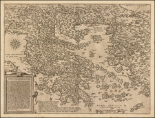
On the eve of Ionian Independence
Fine and highly detailed map of Malta, the Ionian Islands and various other Greek Islands, from Arrowsmith's London Atlas.
Includes a large inset map of the Mediterranean region.
The map details the Ionian Islands during the British period. In 1797 Napoléon Bonaparte conquered Venice. By the Treaty of Campo Formio the islanders found themselves under French rule, the islands being organized as the départments Mer-Égée, Ithaque and Corcyre. In 1798, the Russian Admiral Ushakov evicted the French, and established the Septinsular Republic under joint Russo-Ottoman protection—the first time Greeks had had even limited self-government since the fall of Constantinople in 1453. In 1807, the Ionian Islands were ceded again to the French in the Treaty of Tilsit and occupied by the French Empire.
In 1809, the British defeated the French fleet in Zakynthos (October 2, 1809) captured Kefallonia, Kythera and Zakynthos, and took Lefkada in 1810. The French held out in Corfu until 1814. The Treaty of Paris in 1815 turned the islands into the "United States of the Ionian Islands" under British protection (November 5, 1815). In January 1817, the British granted the islands a new constitution.
Once Greek independence was established after 1830, however, the Ionian islanders began to resent foreign colonial rule by the British, and to press for Enosis, i. e. union with Greece. The British statesman William Ewart Gladstone toured the islands and recommended giving the islands to Greece. The British government resisted, since like the Venetians they found the islands made useful naval bases. They also regarded the Bavarian-born king of Greece, King Otto, as unfriendly to Britain. However, in 1862, Otto was deposed and a pro-British king, George I, was installed.
In 1862, Britain decided to transfer the islands to Greece. On May 2, 1864, the British departed and the islands became three provinces of the Kingdom of Greece though Britain retained the use of the port of Corfu. On May, 21 1864 the Ionian Islands officially reunited with Greece.
Edward Stanford (1827-1904) was a prominent British mapmaker and publisher. A native of Holborn in the heart of London, Edward was apprenticed to a printer and stationer at the age of 14. After his first master died, he worked with several others, including Trelawny W. Saunders of Charing Cross. Saunders oversaw young Edward’s early career, ensuring that he became a Fellow of the Royal Geographical Society. Associations with the Society eventually brought Sanders much business and gave him a reputation as a publisher of explorers. As testament to this reputation, the Stanford Range in British Columbia was named for him by John Palliser.
Stanford briefly partnered with Saunders in 1852 before striking out on his own in 1853. He was an agent for the Ordnance Survey, the Admiralty, the Geological Survey, the Trigonometrical Survey of India, and the India Office. He also controlled the maps of the Society for the Diffusion of Useful Knowledge, another lucrative source of income. In 1857, Stanford founded his namesake Geographical Establishment, with Saunders and A. K. Johnston as engravers. Thereafter, Stanford was known for his “library maps”, particularly those of Africa and Asia.
Addresses and Years of Operation:
- 6 Charing Cross, London (1848): Edward Stanford's initial place of employment at Trelawney Saunders' shop.
- 7 and 8 Charing Cross, London (1853): Stanford expanded his shop to these addresses.
- 55 Charing Cross, London (1873): The shop moved to this larger location.
- 12-14 Long Acre, London (1873): Site of the new print works and current flagship store.
- 7 Mercer Walk, London (2019): Stanfords moved to this address, continuing its legacy.
Stanford's work with Chief Cartographer John Bolton, including the 1858 Library Map of Europe, positioned the company as a leader in quality cartography during a time of exploration and colonialism. Their 1862 Library Map of London earned acclaim from the Royal Geographical Society. With the business thriving, Stanford purchased Staunton & Son in 1877 and, upon retiring in 1885, handed over the reins to his son, Edward Stanford II.
As sole agents for Ordnance Survey Maps, the company's influence and reputation grew, culminating in the Stanford’s London Atlas Of Universal Geography, which was presented to Queen Victoria in 1887. The transition into the 20th century saw further integration of retail, print, and cartographic operations at Long Acre.
During World War I, Stanford's became an essential publisher for the War Office. Edward Fraser Stanford took over in 1917, steering the company through the interwar period and innovations, such as the world’s smallest maps in 1922 and the Daily Mail Motor Road Map in 1926.
Withstanding a bombing in WWII, the company continued under the stewardship of John Keith Stanford and was sold to George Philip & Son in 1947. As it adapted to the digital age, Stanfords received the Ordnance Survey Premier Partner status in 2007 and ventured into online mapping and data services.
Stanfords, now an icon for travellers and explorers, has maintained its cultural relevance and retail success well into the 21st century, underpinned by a legacy of entrepreneurial spirit and commitment to cartographic excellence.

![The Severn or Channel of Bristol [with a chart of the Irish Sea.]](https://storage.googleapis.com/raremaps/img/small/47485.jpg)