|
||

|

|
|

|
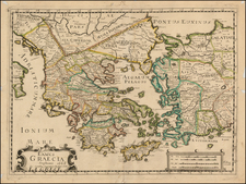
Ionian Isles and Greece, designed by John Tallis and published in London in 1851, encapsulates the rich topography and cultural landscape of Greece and the Ionian Isles during the mid-19th century. Set against the larger geopolitical background, Greece is defined to the north by its border with Turkey, a vestige of the lingering Ottoman dominion. This map is further accentuated by evocative vignettes, including an ancient war chariot, the Temple of Jupiter on Mt. Olympus, Greek Corsairs navigating near Corfu, a contemporary Greek figure, and a scene of wrestlers.
The mid-19th century was a pivotal moment for the region. The decades leading up to this period witnessed Greece's struggle for independence from the Ottoman Empire, culminating in its recognition as a sovereign nation in 1832. This map, delineating the areas still under Ottoman influence, provides a nuanced depiction of the evolving nation-state boundaries. Interestingly, the Ionian Isles, shaded in pink, represent a distinct colonial past, as they were under British jurisdiction during this period. This colonial interlude is further hinted at by the incorporation of their Venetian appellations, such as Corfu, Val di Compare, and Santa Maura.
The map's aesthetics, under the artistic direction of John Tallis, elegantly intertwine with its topographical information. Tallis, renowned as one of the final luminaries in the era of decorative cartography, suffused his maps with detailed vignettes that offer glimpses into the indigenous customs, landscapes, and architectural wonders of the regions they depict. This particular work stands as a testament to Tallis's celebrated style, as it pairs geographical specificity with rich cultural depictions.
Integral to the map's historical context is its association with R. Montgomery Martin's Illustrated Atlas. Martin's atlas, known for its comprehensive coverage and visual richness, lends further gravitas to this specific representation of Greece and the Ionian Isles, framing it within a larger narrative of global cartography and exploration during the Victorian era.
John Tallis (1817-1876) was a British map publisher. Born in the Midlands, Tallis came to London in the 1840s. Tallis began his London career with a series of remarkable London street views. He began a partnership with a Frederick Tallis, possibly his brother, but their collaboration ended in 1849. For the Great Exhibition of 1851, Tallis published the Illustrated World Atlas, one of the last series of decorative world maps ever produced. The maps were engraved by John Rapkin, a skilled artisan. The maps were later reissued by the London Printing & Publishing Company, who left the Tallis imprint intact, thus ensuring his enduring fame. In 1858, he began publication of the popular Illustrated News of the World and National Portrait Gallery of Eminent Personages, selling it in 1861 (it ceased publication in 1863).

![[Cerigo] Ragionevole forme et vera postura del'Isola di Corsica (but actually Cerigo)](https://storage.googleapis.com/raremaps/img/small/74850.jpg)