


|
||

|

|
|

|
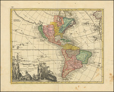
A detailed map of America, by John Arrowsmith. The map shows the lands from "Russian America" to an unclaimed Patagonia, at a time when many parts of the continent were truly wild. Major cities, rivers, islands, lakes, and much more are all shown.
Boundaries have changed much since the making of this map. The Canadian-American border west of the Rocky Mountains is not drawn, though Canada does extend to the Columbia River along the coast. Texas is massive and part of Mexico, though it should have been independent at the time. Guatemala occupies much of Central America. The Gran Columbian dream is on its last legs, with three different republics all faintly demarcated. In reality, they were already independent states. Bolivia reaches the ocean, and the War of the Pacific has yet to be fought to lengthen Chile.
Geopolitical changes are not the only curiosities on this map. Greenland connects to Canadian islands, and Baffin Bay is completely closed. Long rivers flow into the San Francisco bay, including one which crosses the Sierra Nevada and drains from the "Buenaventura Swamp." Many other rivers are conjectured in some of the more remote parts of the map, though most of the Transmississippi West and Canada are shown in great accuracy.
This map is well designed and contains extensive information and detail, typical of Arrowsmith's maps. In all, it is a clear map of the Americas, showing the geopolitical boundaries at the time, but serving as a reminder that even in the 19th century large parts of the continent were still unknown.
The map appeared in John Arrowsmith's London Atlas.
The Arrowsmiths were a cartographic dynasty which operated from the late-eighteenth century to the mid-nineteenth. The family business was founded by Aaron Arrowsmith (1750-1823), who was renowned for carefully prepared and meticulously updated maps, globes, and charts. He created many maps that covered multiple sheets and which were massive in total size. His spare yet exacting style was recognized around the world and mapmakers from other countries, especially the young country of the United States, sought his maps and charts as exemplars for their own work.
Aaron Arrowsmith was born in County Durham in 1750. He came to London for work around 1770, where he found employment as a surveyor for the city’s mapmakers. By 1790, he had set up his own shop which specialized in general charts. Arrowsmith had five premises in his career, most of which were located on or near Soho Square, a neighborhood the led him to rub shoulders with the likes of Joseph Banks, the naturalist, and Matthew Flinders, the hydrographer.
Through his business ties and employment at the Hydrographic Office, Arrowsmith made other important relationships with Alexander Dalrymple, the Hudson’s Bay Company, and others entities. In 1810 he became Hydrographer to the Prince of Wales and, in 1820, Hydrographer to the King.
Aaron Arrowsmith died in 1823, whereby the business and title of Hydrographer to the King passed to his sons, Aaron and Samuel, and, later, his nephew, John. Aaron Jr. (1802-1854) was a founder member of the Royal Geographical Society (RGS) and left the family business in 1832; instead, he enrolled at Oxford to study to become a minister. Samuel (1805-1839) joined Aaron as a partner in the business and they traded together until Aaron left for the ministry. Samuel died at age 34 in 1839; his brother presided over his funeral. The remaining stock and copper plates were bought at auction by John Arrowsmith, their cousin.
John (1790-1873) operated his own independent business after his uncle, Aaron Arrowsmith Sr., died. After 1839, John moved into the Soho premises of his uncle and cousins. John enjoyed considerable recognition in the geography and exploration community. Like Aaron Jr., John was a founder member of the RGS and would serve as its unofficial cartographer for 43 years. Several geographical features in Australia and Canada are named after him. He carried the title Hydrographer to Queen Victoria. He died in 1873 and the majority of his stock was eventually bought by Edward Stanford, who co-founded Stanford’s map shop, which is still open in Covent Garden, London today.
![The Rise, Progress and Prospects of the Republic of Texas [including:] Map of Texas, compiled from Surveys recorded in the Land Office of Texas, and other Official Surveys, By John Arrowsmith. [and:] A Map of the Republic of Texas and the Adjacent Territories, Indicating the Grants of Land Conceded under the Empresario System of Mexico.](https://storage.googleapis.com/raremaps/img/small/94046.jpg)
![[Matagorda Bay: Pictorial Letter Sheet]](https://storage.googleapis.com/raremaps/img/small/40810.jpg)