|
||

|

|
|

|
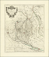
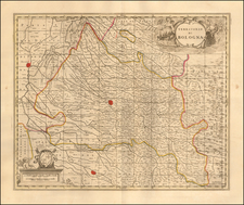
Map showing the Duchy of Modena, Reggio and Carpi in northern Italy, illustrating the roads and pathways utilized by the Italian and French armies throughout the region. The map highlights key fortified zones in and around Modena, Reggio, Parma, and Bologna and illustrates the mountainous regions above Tuscany the armies traveled through. Shows churches, universities, chateaus, lakes, and forests.
Includes an orate cartouche with scale of distances and a directional compass.
Pierre, or Pieter, Mortier (1661-1711) was a Dutch engraver, son of a French refugee. He was born in Leiden. In 1690 he was granted a privilege to publish French maps in Dutch lands. In 1693 he released the first and accompanying volume of the Neptune Francois. The third followed in 1700. His son, Cornelis (1699-1783), would partner with Johannes Covens I, creating one of the most important map publishing companies of the eighteenth century.
![[ Ostia - Ancient Port of Rome ] Claudii Et Traiani Impp Admirabilium Portuum Ostiensium Orthographia Per Stephanum Du Perach Architectum Iuxta Antiqua Vestigia Accuratissime Delineata . . . 1575](https://storage.googleapis.com/raremaps/img/small/102612.jpg)
![[ Istria / Croatia / Slovenia / Fruili ] Forum Iulium Karstia, Carniola Histria et Windorum Marchia](https://storage.googleapis.com/raremaps/img/small/61612.jpg)