


|
||

|

|
|

|
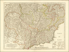
The map titled "Idrogeologica Adige - Garda - Mincio: Convegno Interprovinciale per la Sistemazione Idrogeologica" was published in 1961 by the Cooperativa Tipografica Brescia, located in Brescia, Italy.
The map was created for the "Convegno Interprovinciale per la Sistemazione Idrogeologica," an interprovincial conference focused on the hydrogeological systematization of the Adige, Garda, and Mincio regions. The conference took place on Sunday, April 23, 1961, in Desenzano del Garda.
The map prominently features the Adige River, Lake Garda, and the Mincio River, highlighting the hydrographic network and key locations along these water bodies. Significant towns and cities, including Brescia, Mantova, Verona, and Trento, are marked and represented by the local chambers of labor (Camere del Lavoro) of the Confederazione Generale Italiana del Lavoro (CGIL).
The map uses blue to delineate the water bodies and pathways, emphasizing the hydrological connections between the Adige River, Lake Garda, the Mincio River, and ultimately, the Po River. Major towns such as Peschiera, Monzambano, and Goito are marked with small black squares, while Mantova is illustrated with a notable skyline icon, underscoring its importance.
The text on the map includes details about the conference, such as the date and location (Desenzano del Garda) and the significant role of a CGIL secretary who would conclude the proceedings. The map serves as a practical guide to understanding the geographical focus of the conference discussions on improving and managing the hydrogeological systems in the region.
![[ Hawaii ] Free All Islands Map](https://storage.googleapis.com/raremaps/img/small/99157.jpg)
![(Turin) Nuova pianta della citta di Torino [New Map of the City of Turin]](https://storage.googleapis.com/raremaps/img/small/86314.jpg)
![[ Original Artwork - 37 Hand Drawn Maps By Norton Allen For Desert Magazine ]](https://storage.googleapis.com/raremaps/img/small/99899.jpg)