|
||

|

|
|

|
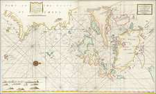
The Definitive French Map of Korea and Manchuria at the outset of the Russo-Japanese War of 1904.
Rare separately issued map of Manchuria, Korea, contiguous parts of China, and Siberia, published in Paris by Librairie Maritime and Colonial Augustine Challamel, at the outset of the Russo-Japanese War of 1904.
The title notes that the map is translated from a Russian General Staff map of the region, published in Harbin. The map was announced in Les Missions Catholiques as follows:
NOUVELLE CARTE DE LA GUERRE RUSSO-JAPONAISE
Mandchourie et Corée - De Kharbine à Séoul. - De PortArthur à Vladivostok.-Echelle : 1 :1.650.000".-Traduction de la Carte de l'Etat-Major Russe. - 1 feuille 92 x 68 eu neuf couleurs- 2 francs; franco par la poste, 2 fr. 25.- Librairie Maritime et Coloniale, Augustin Challamel, Editeur, 17, rue Jacob, Paris. - En vente dans nos bureaux.
Au moment où commencent en Mandchourie les véritables opérations militaires, on ne pouvait mieux faire que de donner une traduction française de la carte dressée par l'Etat-Major Russe (Edition de 1904).
Cette carte nouvelle, publiée par la librairie Challamel, très claire et d'un format maniable (92 x 68) donne toute la région comprise entre Kharbine et Séoul, Port-Arthur,* Vladivostok.
Etudiée au point de vue de la pénétration du pays, cette carte russe est beaucoup plus complète que les cartes des Etats-Majors Français, Allemands ou Anglais. Tout ce qui avoisine les voies de commun ications,chemins de fer routes ou rivières, s'y trouve signalé: les moindres villages, ju fermes, les pagodes, les couvents orthodoxes, tous les points qui peuvent être disputés au cours de la campagne. Le relief du sol ressort admirablement.
Deux cartouches à grande échelle permettent de ??? dans tous leurs détails les opérations autour des deux ports russes.
Cette publication ne fait pas double emploi avec la belle carte d'ensemble publiée par la librairie Challamel au de but des hostilités, et qui donne à l'échelle du 1/6,500,000 tout l'empire du Japon, la Corée, la Mandchourie jusqua l'embouchure de l'Amour, les côtes de Chine jusqu'à Formose, c'est-à-dire le théâtre entier des luttes sur mer.
Translation:
NEW MAP OF THE RUSSO-JAPANESE WAR
Manchuria and Korea - From Harbin to Seoul. . - From Port Arthur to Vladivostok.-Scale: 1: 1,650,000 ".- Translation of the Card of the Russian General Staff - 1 sheet 92 x 68 had nine colors- 2 francs French by mail, 2 fr. 25.- Librairie Maritime and Colonial Augustine Challamel, Publisher, 17, rue Jacob, Paris. - In sale in our offices.
At the beginning of military operations in Manchuria, could not do better than to give a French translation of the map prepared by the General Staff Russian (1904 Edition).
This new map published by the bookstore Challamel, very clear and a handy size (92 x 68) gives all the region between Harbin and Seoul, Port Arthur * Vladivostok.
Studied from a point of view of of penetration of the country, the Russian map is much more complete than the maps of militarty staffs French, German or English. All details of communications channels, railways, rods and rivers are reported: the smallest villages, farms, pagodas, Orthodox convents, and all the points that can be of interest during the campaign. The geographical contours are well excecuted.
Two large scale inset maps show every detail of operations around the two Russian ports.
This publication does not duplicate the beautiful overall library map of Challamel for purpose of hostilities, and which gives the scale of 1 / 6,500,000 while the Empire of Japan, Korea, Manchuria the mouth of the Amur, the Chinese coast to Formosa, that is to say, the entire theater of sea battles.
The Russian edition of the map is a product of the vibrant contemporary Russian political and intellectual interest in the Far East. Russia had maintained a presence in Pacific Siberia since the 18th-century, but it was only in the late 1800s that their influence extended southwards. Following the Sino-Japanese War (1894-5), China's control of its frontier regions was weakened. Russia stepped in to virtually colonize large parts of Manchuria, and while not controlling any of its territory, maintained considerable influence over Korea, which was ruled by the declining Joseon Dynasty.
As a result of Japan's success in the First Sino-Japanese War (1894-1895), the Treaty of Shimonoseki ceded the Liaodong Peninsula from China to Japan.
Soon after the Treaty was signed, Russia, France and Germany forced Japan to withdraw, and Russia in turn occupied the Liaodong Peninsula and constructed Port Arthur, where it relocated its primary fleet in the Pacific, while Germany also set up a base of operations in Jiaozhou Bay. In December, 1897, the Russian fleet appeared off Port Arthur. After three months, in 1898, China and Russia negotiated a convention by which China leased Port Arthur to Russia, along withTalienwan and the surrounding waters. A year later, to consolidate their position, the Russians began to build a new railway from Harbin through Mukden to Port Arthur. The development of the railway became a contributory factor to the Boxer Rebellion, and Boxer forces burned the railway stations at Bob and Roy.
In 1898, the Russians founded Harbin, Manchuria, which became a boomtown sustained by the Trans-Manchurian Railway (a spur of the Trans-Siberian Railway). It soon became the center of Russian financial operations and intellectual pursuits in East Asia.
The Russians and the Japanese were both part of the eight member international force sent in 1900 to quell the Boxer Rebellion and relieve the international legations under siege in Beijing. As with other member nations, the Russians sent troops into Beijing. Russia had already sent 177,000 soldiers to Manchuria, in part to protect its railways under construction. The troops of the Qing empire and the participants of the Boxer Rebellion could do nothing against this massive army. As a result, the Qing troops were ejected from Manchuria and the Russian troops settled in. Russia assured the other powers that it would vacate the area after the crisis. However, by 1903, the Russians had not yet established any timetable for withdrawal and had actually strengthened their position in Manchuria. Over the course of the next 12 months, Japan and Russia negotiated unsuccessfully, leading to a declaration of War by Japan on February 8, 1904. The War lasted until January 1905 and resulted in the surrender of the Russians and termination of its presence in the area around Korea and Manchuria.
![[Map of the Mount Everest Region] Mahalangur Himal Chomolongma -- Mount Everest](https://storage.googleapis.com/raremaps/img/small/95259.jpg)