|
||

|

|
|

|
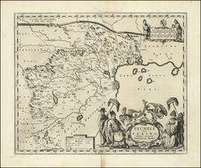
Rare early English sea chart of China's Zhejiang Province, which appeared in an early edition of the The English Pilot: Third Book.
The map shows the area around Zhoushan, including Ningbo, Hangzhou and the area just to the south of Shanghai.
This chart illustrates China's modern day Zhejiang province, located on the East China sea, just south of the Yangtze Delta, an area of tremendous activity and interest for European traders during the eighteenth-century. The map shows the port of Zhousan (Chusan), the location of the entrance of the Grand Canal of China. Constructed in the 5th-century B.C., the Canal was then the oldest and longest man-made waterway in the world, which allowed barges to travel hundreds to Beijing.
In 1671, John Seller commenced work on The English Pilot, which was planned as a four volume sea atlas covering different regions of the globe, Seller's first part, entitled the Oriental navigation, first appeared on the market in 1675. Before further maps could be produced, Seller sold the plates to John Thornton, the official hydrographer to the English East India Company. Over the net decades, Thorton expanded the work, issuing the first edition of the Third Book, detailing navigation in the East Indies in 1703.
While Thornton largely based his charts on those of earlier Dutch cartographers, most notably those found in Pieter Goos' Zee-Spiegel and Lucas Janz Waghenaer's Mariner's Mirror, The English Pilot proved to be enormously popular. When John Thornton died in 1708, his brother Samuel continued the work and expansion of the book, ultimately selling out to Mount & Page, who continued the work for over half a century.
John Thornton was a respected and prominent chartmaker in London in the latter part of the seventeenth century. He was one of the final members of the Thames School of chartmakers and served as the hydrographer to the Hudson's Bay Company and the East India Company. He produced a large variety of printed charts, maps, and atlases in his career, but he was also a renowned manuscript chart maker. Born in London in 1641, he was apprenticed in the Drapers Company to a chartmaker, John Burston. After being made free of the company (1665), he was part of the combine that took over John Seller’ English Pilot in 1677. Thornton was trusted by the naval and navigational establishment of the day; one of his clients was Samuel Pepys, naval administrator and diarist. Thornton died in 1708, leaving his stock to his son, Samuel, who carried on the business.
Samuel, born in ca. 1665, also had apprenticed in the Drapers Company and was made free a year after his father’s death. He continued the business until 1715, when he died. His stock then passed to Richard Mount and Thomas Page.
![The Map of China [Huang Ming yitong fang yu bei lan -- Comprehensive view map of the Imperial Ming]](https://storage.googleapis.com/raremaps/img/small/99110.jpg)
![[English Edition!] Chinae, olim Sinarum regionis nova descriptio. auctore Ludouico Georgio.](https://storage.googleapis.com/raremaps/img/small/71123.jpg)