|
||

|

|
|

|
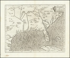
Nice example of the northwestern sheet from the Covens & Mortier's edition of Henry Popple's seminal map of North America.
The map is centered on the course of the Mississippi River, from the Arkansas River to the area north of Lake Winnepeg and Hudson's Bay. The map reaches east to the Appalachians, Lake Erie, Lake Ontario and the Carolina Coast south of Cape Fear and west to the Upper Rio Grande in New Mexico.
The map provides an interesting look at the 5 Great Lakes, only a few years prior to Nicolas Bellin's map of 1744 and 1764, which would significantly redefine the shapes of the lakes.
The map offers a look at the best known topographical detail in the interior, also naming dozens of Indian, French and English settlements in the Mississippi and Ohio River Valleys at a time when these regions were still largerly part of a great unknown and unexplored western frontier.
Henry Popple's 20 sheet map of North America is widely regarded as one of the two most famous maps of North America to appear in the 18th Century (along with Johns Mitchell's map). It is widely regarded as a landmark in the mapping of North America, being the first large format English map of North America.
Popple produced the map under the auspices of the Lord Commissioners of Trade and Plantations to help settle disputes arising from the rival expansion of English, French, and Spanish colonies. Increased French exploration and the activities of the fur-traders in the Mississippi valley heightened English fears . . . , since France claimed not only Canada, but also the territories drained by the Mississippi and its tributaries - in practical terms, an area half the continent. England and France disputed for many years the fishing rights off Nova Scotia and the Grand Banks.
Added to these problems was the constant threat of attacks on colonists' settlements by Indians allied to the French, leading to the establishment of several frontier forts in the Ohio valley region.
The map was first issued in 1733 in 20 sheets, plus a key sheet. The only other multiple sheet edition of the map is this example offered by Covens & Mortier, who re-issued the primary map in 4 sheets.
Covens & Mortier was one of the largest and most successful publishing firms in Dutch history and continued in business for over a century. Pierre Mortier the Elder (1661-1711) had obtained a privilege in 1690 to distribute the works of French geographers in the Netherlands. After his widow continued the business for several years, Cornelis (1699-1783) took over in 1719.
In 1721, Mortier forged a partnership with Johannes Covens (1697-1774), who had recently married Cornelis’ sister. They published under the joint name of Covens & Mortier. In 1774, upon the death of his father, Johannes Covens II (1722-1794) took over his father’s share. In 1778, the company changed its name to J. Covens & Zoon, or J. Covens & Son.
Covens II’s son, Cornelis (1764-1825), later inherited the business and brought Petrus Mortier IV back into the fold. Petrus was the great-grandson of Petrus Mortier I. From 1794, the business was called Mortier, Covens & Zoon, or Mortier, Covens, & Son.
The business specialized in publishing French geographers including Deslisle, Jaillot, Janssonius, and Sanson. They also published atlases, for example a 1725 reissue of Frederik de Wit’s Atlas Major and an atlas, with additions, from the works of Guillaume Delisle. There were also Covens & Mortier pocket atlases and town atlases. The company profited from acquiring plates from other geographers as well. For example, the purchased Pieter van der Aa’s plates in 1730. Finally, they also compiled a few maps in house. At their height, they had the largest collection of geographic prints ever assembled in Amsterdam.
![[New England] Tierra Nueva](https://storage.googleapis.com/raremaps/img/small/64626.jpg)
![[ Used by '49ers To Travel To California ] Map of Oregon and Upper California from the surveys of John Charles Fremont and others authorities drawn by Charles Preuss 1848](https://storage.googleapis.com/raremaps/img/small/100557.jpg)