|
||

|

|
|

|
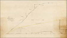
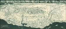
Used in 1849 To Travel To the Gold Regions
Nice example of Fremont's map of the region west of the Rocky Mountains, widely regarded as the most important and influential map the American West published in the middle of the 19th Century.
The present example was apparently used on an overland trip to California to the gold regions in 1849 by portrait artist Charles Weigandt and German immigrant Caspar Limpert. The present example bears inscriptions on the verso noting:
Charles F. Weigandt. Jackson Miss. 1849
Caspar Limpert of Ann Arbour, Mich & Groveport, Ohio
Carried by them on the trip to Calif in the "Gold Rush"
Charles F. Weigandt
The name Charles F. Weigandt (1811-1892) first appears in the Jackson published Weekly Mississippian on August 10, 1843, where he is listed as "an instructor in Drawing and Painting." The size of his advertisements become larger with time, emphasizing portrait painting up to 1846. There is a gap of nearly 20 years, before his name begins to appear again in several Virginia and Maryland newspapers, giving notice of his paintings.
Several of Weigandt's portraits hang in the National Portrait Gallery in Washington.
Caspar Limpert
Caspar Limpert seems to have been an immigrant who came to the United States in 1833. We locate the following entry in the Washtenaw County Hitorical Society Newsletter for September 2009
Three weeks ago I gave notice to my master, whereupon we both were nearly dissolved in tears," wrote Caspar Limpert in 1833 before embarking on his move across the ocean to an unknown land. "We will leave from Bremen for Baltimore or New York. What fate is destined for me in America, I do not know. Limpert was welcomed by 40 other German families already living in Ann Arbor. . . .
Fremont's map was originally published to accompany Fremont's Geographical Memoir upon Upper California.
The map and Geographical Memoir have a two-fold importance in history, first as contributions to geographical knowledge in the year 1848, and second as historic documents concerning Fremont's notable 3rd expedition… [The map] is a wonderfully graphic report on where the expedition of 1845-46 went and what it saw… As a contribution to cartographical knowledge, the case for the map was well put by Fremont himself: 'The map has been constructed expressly to exhibit the two countries of Oregon and the Alta California together. It is believed to be the most correct that has appeared of either of them; and it is certainly the only one that shows the structure and configuration of the interior of Upper California'" (Wheat). Schwartz calls it an "epochal" map and states that the map is the "most accurate general map of the Far West for its time" (Schwartz and Ehrenberg, The Mapping of America, 275, 278).
As noted by Wheat,
More than any other persons, John Charles Fremont and Charles Preuss dominate the cartography of the American West during the three years before the Gold Rush and brought a human tide surging into that land which had so long lain beyond the ken of most Americans" (Wheat, Mapping of the Transmississippi West, 523).
The northern and southern borders are outlined in green, as is the border between Oregon and California and the eastern boundary of the Rocky Mountains, the South Pass and Sierra Madre. At the top of the map is an elevation profile of the route from the South Pass to San Francisco. Both the Plumas and American Rivers show areas marked "'El Dorado' or Gold Region," one of the earliest graphic announcements of the discovery of gold in California. According to Howes, this Preuss map was "not issued in all copies, if any, [of Fremont's Geographical Memoir] but [was] intended to accompany the pamphlet" (Howes F366). Graff lists a first edition copy of the Fremont work with first issue Preuss map laid-in as well as an identical copy of the map issued separately.
As noted in Paul Cohen's excellent compilation of the maps of the West:
"This important and beautifully drawn map became the model for many of the later gold region maps. The California portion is based on Fremont's map of 1845, but the legend 'El Dorado or Gold Rush Region' has been added along the 'Rio d. l. Plumas' (Feather River), and the 'R. d. l. Americanos' (American River), which is shown flowing out of 'Lake Bonpland' (Tahoe) The map covers the territory from the boundary of the 'British Possessions' on the north to the Mexican border on the south, and from the Pacific Ocean on the west to Fort Laramie and the "Great Plains" on the east (Wheat)."[B]y far the most accurate map of the Far West up to the time of its publication The rapidly changing political character of the West is not neglected on the map. 1848 was a milestone year for establishing United States territories and boundaries, and the recognition of these most recent developments make the map an up-to-date document. 'Oregon Territory' established by Congress on August 114, 1848, is clearly delineated, as are the boundaries with Mexico laid out by the Treaty of Guadalupe Hidalgo. Missouri Territory is also indicated, as was, for the first time on a published map, the presence of the Mormons in the Great Basin."