|
||

|

|
|

|
"A Document of the Highest Human Interest" (Carl Wheat)
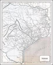
Forgery or Archival Copy? -- Pedro Vial's Lost Map of Texas and the Transmississippi West
Interesting manuscript copy of Pedro Vial's seminal map of Texas and the Transmissisippi West, as presented by Vial to the Governor of New Mexico following Vial's journey from San Antonio to Santa Fe in 1787.
Vial's map covers the region from the Rio Grande to the Mississippi and bound by the Missouri River on the north and the Gulf of Mexico on the south. Indian tribes, Spanish forts, and presidios are located.
Vial's map is of the highest importance. Moreover, as the Vial map was lost sometime in the 20th Century, only the manuscript copies of the map survive.
While it is possible that this example was made by an early copyist working in Montcalvo or some other early Mexican depository, we believe the map was drawn to deceive. While the paper is from the early part of the 19th Centuy, the handwriting is more suggestive of the 20th Century. As such, our opinion is that this map was drawn by a 20th Century forger, with the intent to deceive.
The Vial Map
Vial's map is one of the great modern cartographic mysteries. Vial's history is largely unknown as are the sources for his map. To compound matters, his original map, which was available to copyists in the 19th Century, is seemingly now lost.
What is known is that Pedro (Pierre?) Vial, a Frenchman who travelled extensively in Texas and New Mexco, was known to have created three remarkable early maps of the region. As noted by Carl Wheat:
Early in 1787 a Frenchman by the name of Pedro (Pierre?) Vial turned up at Santa Fe with letters to the Governor of New Mexico from the Governor of Texas. Apparently for some time he had been acquainted with the country around the Natchitoches, the French settlement on the lower Red (Rojo or Roxo) River. He also had dealings with the Indians living westerly from that settlement, notably the Taovayas.
In the Fall of 1786, Gial found himself in San Antonio, and there the Governor, one Cabello, instructed him and a certain Cristobal de los Santos to proceed to reconoitre a practicable route to Santa Fe. The party left San Antonio on October 4, 1786, and took a somewhat circuitous route, during which they ascended a river which, while they were on it, they thought was the Re, but which was in reality the Southern Canadian, and on May 26, 1787, they arrived at Santa Fe where Vial delivered to the Governor the letters from the Texas Governor, along with his diary, and a map of his route.
Unfortunately, this earliest of the three probable Pedro Vial maps has apparently been lost, but that Fall, while Jose Mares was trying to find a more direct route to San Antonio, Vial sat down in Santa Fe and drew a map that is not only a document of the highest human interest, but is one that presents problems affording much food for thought. It is dated "St. Tafee" October 18, 1787, and it purports to show the Mississippi watershed and a portion of that of the Rio Grande, with the intervening territory. Two things about this map are of interest: first, the Red River, with its two upper branches seems relatively clarified, and second, the Missouri River is shown rising in high western mountains and flowing near settlements termed "Riqura" and "Maundane." That a Frenchman come from Louisiana to Santa Fe might have learned of the Arikaras before 1787 is conceivable; that such a man could in 1787 have known of the Mandans poses a problem of no mean dimensions.
Let it be recalled that Verendrye had reached the Mandan villages from the east and north many years earlier, and that he surmised that the great river flowing past the Mandans might be the Missouri. However, so far as is known, little knowledge of his exploits reached the French (after 1762 the Spanish) settlements on the Mississippi, and cerrtainly no map orginating in Louisiana had by 1787 disclosed knowledge of the Mandans. Indeed, it has long been thought that it was not until 1792, when Jacques d'Eglise returned from his tour of the Upper Missouri, that Verendrye's prescient surmise respecting the connection of the lower Missouri with the great river flowing past the Mandan villages was finally proved to have been correct. Vial's map therefore opens the door for a new and interesting speculation. How and what did this unlettered Frenchman at Santa Fe know in 1787 of the Mandans and of the mountains behond them? The answer is not readily apparent. In fact, the mystery deepens the more deeply the problem is explored.
Although bare mention of the "Mantanes" or "Mantans," stemming from Verendrye material was contained on certain earlier European maps, it was not until 1785 that these settlements received specific cartographic attention -- and this on a map drawn by a Yankee official of the British North West Company. For it was in that year . . . that Peter Pond drew his map of the fur country that he gave to Lord Hamilton, and which is now in the Public Records Office in London. On this map, east of a legend to that effect that "Here abouts the Missouri takes its source out of the Mountains," appear the words "Here upon the Branches of the Missouri live the Maundans, who bring to our Factory at Fort Epinett on the Assinipoil River Indian Corn for Sale. Our People go to them with loaded Horses in twelve days." It is not to be supposed that Pedro Vial had knowledge of Pond or of the British fur traders. It is not even credible that Verendrye's earlier discovery might have filtered half the world across and back to Louisiana in such fashion as to enable Vial to draw a passable map showing the Mandans on the Upper Missouri. Perhaps the explanation is that hints and rumors of the Upper Missouri and its people had reached St. Louis through French traders and voyageures several years before the return of the earliest recorded Louisiana up-river expedition to see the Mandans, which occurred in 1792. Apparently the records do not support this notion, but it seems the most logical one for tenative adoption. Lacking information as to Vial's antecdents, or even how or when he came to San Antonio, we can only state this problem, which looms more portentously as we continue unsuccessfully to seek its solution.
As noted by Wheat, Vial's map was reproduced by Dr. Carlos Casteñeda on two occasions, noting the original was in the Archivo General de Mexico, subsequent searches by scholars have failed to locate the original map. Wheat relied on a photostatic copy at the New Mexico Historical Society, which was reportedly drawn from a private Mexican collector.
The present example was acquired in about 2005 but was not offered for sale until 2024. At the time of purchase, it was believed to be a 19th or 20th century copy, as the paper was clearly not 18th Century. The lore of the map at the time of its purchase was that it had been acquired by a Texas collector in the mid-20th Century, but without documentation or provenance.
It had been hoped that the map could be attributed to one of several famous forgers of Texas documents, but to date, no compelling evidence of its origin has come to the fore. As mentioned above, there is also a chance that it was created from the original or one of the surviving copies at a relatively early date by a scholar or otherwise for preservation purposes, but we believe far more strongly that it was made to deceive.
Dating The Paper
The present example has a G.C. Cini watermark. G & C Cini was a Tuscan paper firm, which operated in the 1830s and 1840s, in San Marcello Pistoiese. Established by the Cini family, this was the first paper mill in Italy to install a Fourdrinier machine, see Angelo Nesti, La cartiera Cini de La Lima (PT). Uno studio archeoindustriale, Firenze, Edizioni Polistampa, 2005.
Conclusion
The present example is a marvelous artifact of Texas and Western American history, either as a later copy of one of the most important maps of the late 18th Century and/or as part of the more modern history of Texas forgeries. In either case, it is one of the few surviving copies of the Vial's lost map of Texas and the Tranmississippi West.
Pedro Vial, or Pierre Vial is a fascinating early figure in the history of the exploration and mapping of the Great Plains.
Living extensively among the Comanche and Wichita Indians, including the Taovaya tribe, Vial gained unique insights into their languages and cultures. His skills as a gunsmith and his fluency in French, Wichita, and Spanish enabled him to serve effectively as a peacemaker, guide, and interpreter for the Spanish government, fostering connections between the Spanish and French territories in Texas, New Mexico, Missouri, and Louisiana.
Vial's known history began in 1779, following his visits to Natchitoches and New Orleans, Louisiana, where Spanish authorities noted his residency among "savage nations." His initial engagements with the Taovaya on the Red River at Spanish Fort, Texas, and in Jefferson County, Oklahoma, marked the start of his deep involvement with Native American communities. By Autumn 1784, Vial was in San Antonio, Texas, working to improve relations between the Wichita and the Spanish. His subsequent peace mission with Francisco Xavier Chaves—a Spaniard with a unique upbringing among the Wichita and Comanche—to the Comanche in 1785 led to a peace agreement that significantly impacted Spanish-Native American relations for decades.
In 1786, Vial embarked on a pioneering journey from San Antonio to Santa Fe, New Mexico, marking the first recorded European traversal of the Great Plains along this route. This expedition, which saw him issuing warnings to the Taovaya and wintering among the Comanche, laid the groundwork for future travel and trade routes. His travels did not stop there; Vial continued to forge paths between significant locations, including a journey from Santa Fe to Natchitoches in 1788, and another from Santa Fe to St. Louis in 1792, encountering Francisco Xavier Chavés and various Native American tribes along the way.
Vial's later years were marked by continued service and exploration, even as he faced suspicion and arrest by Spanish authorities in 1795. His attempts to intercept the Lewis and Clark Expedition in the early 1800s on behalf of Spain showcased his enduring commitment to his roles as an explorer and diplomat. Despite facing challenges, including attacks by unidentified Native American tribes in 1805 and the eventual abandonment of a large expedition in 1806, Vial remained a pivotal figure in the Spanish frontier.
Upon the U.S. acquisition of the Louisiana Purchase, Vial adapted to the changing political landscape, receiving a trapping license from Meriwether Lewis in 1808 and continuing his work as an interpreter and guide. His final days were spent in Santa Fe, where he passed away in October 1814.
![[Original photograph] Native Americans, possibly Creeks, in outdoor camp with white settlers or Indian Agents.](https://storage.googleapis.com/raremaps/img/small/78740.jpg)