
This item has been sold, but you can enter your email address to be notified if another example becomes available.


|
||

|

|
|

|
Stock# 3473
Description
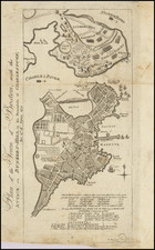
Scarce regional map, colored by counties and showing towns, mountains, rivers, railroads, etc. This map was originally engraved in the late 1850s as part of a wall map by Rogers & Johnston, and represents a unique and long running collaboration between American and British cartographic publishers.
![[Right sheet only of: A New Chart of America Florida to New York with the Principal Harbours on a Large Scale, Drawn from the latest Authorities, by Robt Blachford. 1807.]](https://storage.googleapis.com/raremaps/img/small/55819.jpg)
![[New England] Tierra Nueva](https://storage.googleapis.com/raremaps/img/small/64626.jpg)
![[East Coast & Canada ] Tierra Nueva](https://storage.googleapis.com/raremaps/img/small/104342.jpg)