
![Nova Totius Terrarum Orbis Geographica Ac Hydrographica Tabula. A Pet. Kaerio [First State -- With Handwritten Account of Sir Francis Drake's Voyage on the verso] By Pieter van den Keere](https://storage.googleapis.com/raremaps/img/small/81200.jpg)


|
||

|

|
|

|
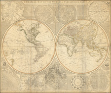
Rare example of Pieter van den Keere's decorative map of the World, first issued in 1608. The present edition was issued by Jan Jansson in 1628, and is considered to be one of the supreme examples of the golden era of Dutch Baroque cartography.
Stylistically, the map is skillfully derived from Willem Blaeu's single page map of 1608, but features alterations to the cartouches and decorative embellishments. The panels that run along all sides of the map are rich with allegorical adornment. Across the top are vignettes of the known solar system, including:
- Luna (the Moon),
- Mercurius (Mercury),
- Venus, Sol (the Sun),
- Mars,
- Jupiter
- Saturnus (Saturn).
The panel to the left depicts the four earthly elements:
- Igis (Fire),
- Aer (Air),
- Aqua (Water)
- Terra (Land).
The panel to the right of the map depicts the four seasons:
- Ver (Spring),
- Aestus (Summer),
- Autumnus (Fall)
- Hyems (Winter).
The panel that runs along the bottom of the map features the Seven Ancient Wonders of the World;
- Murus Babyloniae (The Hanging Gardens of Babylon, Nineveh, Iraq),
- Colossus (Colossus of Rhodes, Greece),
- Pyramides (the Great Pyramids of Gizeh, Egypt),
- Mausoleum (Mausoleum of Halicarnassus, Bodrum, Turkey),
- Dianae Templum (Temple of Diana, or Athena, Izmir, Turkey),
- Jupiter Olympicus (State Statue of Jupiter, or Zeus, Olympia, Greece)
- Pharos (The Great Lighthouse of Alexandria, Egypt).
Cartographically, the map is drawn from Petrus Plancius's wall map of 1592. The map incorporates some of the classic cartographic misconceptions of the period, including an elongated Northwest Coast of America, a massive mysterious southern continent (Antarctica) with a very narrow strait between it and South America, as well as an incomplete New Guinea that is attached to the southern continent.
The map features a lengthy notation to the left and right of the large cartouche titled 'America' that discusses whether in fact the apocryphal Anian Straits (at the location of modern-day Alaska) and the Davis Straits actually join to form the Northwest Passage. Related to this aspect, a sprinkling of English names in the Canadian Arctic is included as a result of Martin Frobisher and John Davis's explorations in search of the Northwest Passage in 1576-1587.
Notable improvements to Plancius' map include the discoveries of the voyages of Willem Barents (1594-1597) in the Russian Arctic, notably the correct depiction of Novaya Zemlya as an island, with open sea lying between it and the North Pole. Both the Arctic and Antarctic Circles are detailed in insets towards the lower corners of the map.
The map was originally issued by Pieter van den Keere and dated 1608. The Le Maire Straits that run to the east of the Tierra del Fuego, discovered by Jacob Le Maire and Willem Schouten in 1616, were added to the plate in 1621. Thereafter, the plate was sold to Jan Jansson, who used the map in only a few early editions of his atlas.
All editions are rare on the market.
Jan Janssonius (also known as Johann or Jan Jansson or Janszoon) (1588-1664) was a renowned geographer and publisher of the seventeenth century, when the Dutch dominated map publishing in Europe. Born in Arnhem, Jan was first exposed to the trade via his father, who was also a bookseller and publisher. In 1612, Jan married the daughter of Jodocus Hondius, who was also a prominent mapmaker and seller. Jonssonius’ first maps date from 1616.
In the 1630s, Janssonius worked with his brother-in-law, Henricus Hondius. Their most successful venture was to reissue the Mercator-Hondius atlas. Jodocus Hondius had acquired the plates to the Mercator atlas, first published in 1595, and added 36 additional maps. After Hondius died in 1612, Henricus took over publication; Janssonius joined the venture in 1633. Eventually, the atlas was renamed the Atlas Novus and then the Atlas Major, by which time it had expanded to eleven volumes. Janssonius is also well known for his volume of English county maps, published in 1646.
Janssonius died in Amsterdam in 1664. His son-in-law, Johannes van Waesbergen, took over his business. Eventually, many of Janssonius’ plates were sold to Gerard Valck and Pieter Schenk, who added their names and continued to reissue the maps.
![[ Pacific Ocean Centric World Map ] Mappe-Monde Sur la Projection de Mercator Carte Encyprotype Dediée et Présentée à Monsieur](https://storage.googleapis.com/raremaps/img/small/69294.jpg)