|
||

|

|
|

|
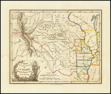
Large map of the Mississippi, from the Missouri to its source in the north, from the first French edition of Pike's classic account of the first U.S. government expedition to the Southwest (first edition, Philadelphia, 1810).
The maps in the French edition of Pike's account are corrected and much improved from the American edition, which also incorporates the information furnished by Lewis and David Thompson (whose map for the Hudson Bay Company in 1798 is one of the most important pre-Lewis & Clark source maps). The map was drawn by Nicholas King, whose post Lewis & Clark manuscript maps are among earliest and most important to incorporate Lewis's reports. Pike's map, unlike Humboldt's, was based primarily on firsthand reconnaissance, an element always present in the progress of geographic knowledge of the American West. The map is a more attractive and better engraved work than the prior American edition, and is at least as rare.
![[ Gulf Coast & West Coast of Florida ] De Cust van Westindien Van La Desconoscida, tot C. Escondido. . .](https://storage.googleapis.com/raremaps/img/small/65741.jpg)

![[Alabama, Mississippi, Arkansas, Louisiana and part of Tennessee and Western Florida] Amer. Sep. No. 56 Partie des États Unis](https://storage.googleapis.com/raremaps/img/small/93538.jpg)