|
||

|

|
|

|
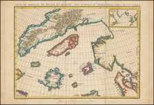
Nice example of Muller's seminal map of the North Pacific and contiguous coasts of America and Asia, published in St. Petersburg, the first official map to reflect the results of Russia's Great Northern Expedition.
The Great Northern Expedition was one of the largest and best organized voyages of exploration, the results of which completely remapped most of the Arctic coast of Siberia and some parts of the Northwest coast of America, filling in vast amounts of previously unknown coastal details, which had been previously the subject matter of myth and speculation. Originally conceived by Russian Emperor Peter I the Great, the exploration was undertaken under the auspices of Russian Empresses Anna and Elizabeth, under the direction of Vitus Bering. The expedition lasted roughly from 1733-1743. The goal was to find and map the eastern reaches of Siberia, and explore and map the Northwest Coast of America.
The important achievements of the expedition included the European discovery of Alaska, the Aleutian Islands, the Commander Islands, Bering Island, as well as a detailed mapping of the northern and north-eastern coast of Russia and the Kuril Islands. The expedition also ended the myth of a massive land mass in the North Pacific.
First published in 1754, Muller's map was the official Russian response to Joseph Nicolas Delisle's surreptitious publication of his map of the region. The Russians believed that Delisle had improperly used the information he had gathered while serving in St. Petersburg at the Royal Academy. Moreover, they were aware of his incorrect delineation of the Northwest Coast of America. Thus they encouraged Gerard Muller, a German cartographer working in St. Petersburg, to issue a map to correct Delisle's mistakes, as the official mapping from the Imperial Academy in St. Petersburg.
Muller's map was first issued in 1754, then reissued in 1758, 1773, and again in 1784. The 1773 and 1784 editions were significantly updated, especially to show the discoveries of a number of Russian explorations, beginning in 1764, which produced new information on the Aleutian Islands and the western coast of Alaska.
The first edition of Muller's map shows a dotted line suggesting the coast of America extending well to the west. The Russian explorations of the 1760s would later determine that the coastline was further to the east, leading to significant revisions of the map.. At the same time, the Russian explorer Ivan Synd, reported the existence of a number of fictitious islands in the middle of Bering's Strait, which were incorporated into the second edition of the map.
Muller's map is noteworthy in its omission of Delisle's mythical "Sea of the West," although he does continue to hold out hope for a water route from the Pacific to the Atlantic via tentatively located "R. de l'Quest" connecting the northern California coast ultimately to Hudson's Bay.
Streeter notes that Muller's map
confirmed the existence of a body of water between Asia and America, the subject of much dispute during the previous two hundred years. It also showed the Kurile Islands correctly and suggested the outline of Alaska and the Aleutian chain. Though the Russian discoveries had been shown on the Delisle map . . .published in 1752, . . . this is the first map to give an approximate picture of what is now the Alaska peninsula. . . .
A foundational map for collectors of the Northwest Coast of America and Northeast Coast of Asia.
![(Central Asia and Russia) Tabula Asiae VII [Seventh Map of Asia]](https://storage.googleapis.com/raremaps/img/small/94381.jpg)
![Carte Du Canada ou de la Nouvelle France et des Decouvertes qui y ont ete faites . . . [Map of Canada or New France and the Discoveries Made Therein . . .]](https://storage.googleapis.com/raremaps/img/small/94450.jpg)