|
||

|

|
|

|
Stock# 32711
Description
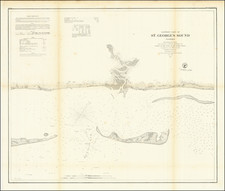
Early separately issued sea chart of the Gulf Coast, published by Edmund Blunt in New York in 1830.
The map covers the Gulf Coast from the Mouth of the Mississippi and New Orleans in the west to Fort St. Marks, near modern day Tallahassee. A number of light houses are identified in red and gold.
According to Guthorn, the chart was first issued by Blunt in 1815, at which time it was one of the earliest American Sea Chart to cover the Gulf Coast. We have located editions dated as late as 1837. All editions are extremely rare, with only one example listed in OCLC (1823-Massachusetts Historical Society).
Condition Description
Linen backed sea chart.
Reference
see 33176mb