
The item illustrated and described below is sold, but we
have another example in stock. To view the example which
is currently being offered for sale, click the
"View Details" button below.


|
||

|

|
|

|
Stock# 31910
Description
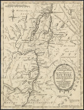
Finely detailed map showing the region of New York between Albany and Fort Ticonderoga during the American Revolution.
The map shows towns, roads, rives, mills, Fort Massachusetts, Ft. Miller, Ft. Hardy, Fort Edward, Ft. Amherst, Ft. Anne, Ft. George and Ft.Ticonderoga.
Reference
Jolly, D.C. (Brit Per) LOND-320.
![[ First Map of Pennsylvania Province ] A Map of the Province of Pensilvania Drawn from the Best Authorities By T. Kitchin Gr.](https://storage.googleapis.com/raremaps/img/small/98226.jpg)

![(Civil War) Fredericksburg … [with] Map… of the Sioux Expedition [with] Map of the Fight of the 14th A.C. Buzzard Roost, GA [and ] Big Mound [and] Dead Buffalo Lake [and] Dry Fort Creek](https://storage.googleapis.com/raremaps/img/small/97072.jpg)
