


|
||

|

|
|

|
Stock# 101821
Description
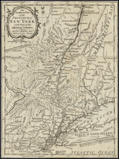
Finely detailed map showing part of the Colony of New York between Albany and Fort Ticonderoga during the American Revolution.
The map shows towns, roads, rivers, mills, Fort Massachusetts, Ft. Miller, Ft. Hardy, Fort Edward, Ft. Amherst, Ft. Anne, Ft. George and Ft.Ticonderoga.
At the bottom right, the NB notes "Situations uncertain have a Line drawn under the name." These include:
- Bennington (Battle of Bennington, August 16, 1777)
- Santcoick (Probably Walloomsac, New York on the Hoosick River)
- Castletown
- Huberton (Battle of Hubbardton, July 7, 1777)
Condition Description
Very minor foxing around edges. Trimmed to the neatlines.
Reference
Jolly, D.C. (Brit Per) LOND-320.

![[Seneca Falls / Bayard Land Company] A Map of Lot No. 6 Cayuga Reservation West](https://storage.googleapis.com/raremaps/img/small/58121.jpg)
![(New York-Robert C. Livington) [Revolutionary-Era Land Indenture]](https://storage.googleapis.com/raremaps/img/small/91957.jpg)