This item has been sold, but you can enter your email address to be notified if another example becomes available.


|
||

|

|
|

|
Stock# 30059
Description
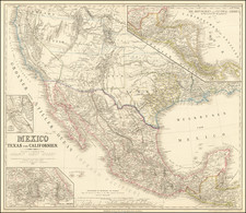
Attractive map of Texas and Indian Territory, colored counties, from Historical Illustrated Atlas of the World.
Nice detail throughout Texas, including early railroad lines.
Notes that Indian Territory was ceded to U.S. in 1866. Shows towns, railroads, rivers, forts, mountains, Indian names, etc.
![(Western Frontier Military Archive) [Original diaries and bound volumes of General Orders: Civil War, Atlanta campaign with the 14th Colored Infantry; Bureau of Refugees and Freedmen, Washington & Nashville; Austin, Texas; Fort Laramie, Wyoming Territory; Montana Territory; Portland, Oregon; Fort Vancouver, Fort Walla Walla & Fort Colville, Washington Territory; Camp Douglas, Utah Territory]](https://storage.googleapis.com/raremaps/img/small/99887.jpg)