|
||

|

|
|

|
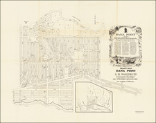
Remarkable large format map of Newport Beach, California, showing the lines of Pacific Electric Railway extending beyond the Pavilion & Bath House to the Newport Bath House & Boat House.
The map is from a collection of maps de-accessioned by the Southern Pacific Railroad Company, including old maps formerly owned by the Pacific Electric Railway Co. This map would seem to show the proposed extension of the Red Car Line to the Balboa Pier.
The map provides a fantastic early snapshot of Newport Beach during its earliest boom times, including early land owners, lot subdivisions, and a host of other important early details. The unique redlining of the map makes it a fantastic and important early Orange County artifact.
The map was drawn by Ben F. Dupuy, was a Civil Engineer who graduated from Ohio State University, whose early work was with the railroads. Before coming to Southern California, he worked as an engineer on the Truckee-Carson Project circa 1905. After coming to Southern California, he produced a map of South Pasadena, circa 1910, and was the city engineer in Long Beach in 1914. In 1922, he beame the City Engineer of Glendale, California.
In 1871 a steamer named The Vaquero made its first trip to a marshy lagoon for trading. Ranch owners in the Lower Bay decided from then on that the area should be called "Newport." In 1905 city development increased when Pacific Electric Railway established a southern terminus in Newport connecting the beach with downtown Los Angeles. In 1906 with a population of 206 citizens, the scattered settlements were incorporated as the City of Newport Beach.
![[Southern California] Map of Automobile Roads Banning California](https://storage.googleapis.com/raremaps/img/small/45357.jpg)
![California and Nevada [Yosemite, Sacramento, and San Francisco Insets]](https://storage.googleapis.com/raremaps/img/small/79443.jpg)