


|
||

|

|
|

|
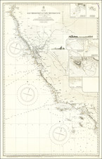
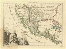
Rare variant edition of this marvelous map of Mexico and the Western US.
The first edition of Malte-Brun's map incorporates the information from Humboldt, Pike and Lewis & Clark. It is the earliest known map to show a continuous waterway from the Great Salt Lake to San Francisco Bay, the mythical Rio Buenaventura.
In this rare second edition, there are significant changes. The name Louisiana is removed and the Missori river shows the Big Bend, reflecting the information from Lewis & Clark's expedition. The mountain ranges in the area of Utah and Nevada have been removed, as have the apocryphal rivers, perhaps based in part on information derived from Arrowsmith. A definitive "Adams Onis" northern border between the US and Upper California is shown, whereas there has been no boundary in the earlier edition. Lake Teguayo and Timpanagos are much more boldly shown and are depicted in their large and more familiar shape.
A link to the earlier edition can be found here : /gallery/detail/26795
Malte-Brun's maps are often overlooked, despite his tireless efforts to provide up to date cartographic information.
![[Arizona below New Mexico] Mexique d'apres le grand Atlas Dresse Par A.H. Dufour Grave par ch Dyonet Pubie par A. Le Chevalier . . . 1863](https://storage.googleapis.com/raremaps/img/small/64395.jpg)