|
||

|

|
|

|
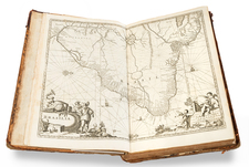
Rare set of three 4-sheet maps of the counties of Jamaica (Surrey, Cornwall and Middlesex), prepared by order of the Lieutenant Governor of Jamaica between 1756 and 1761, which show the results of the first detailed survey of the whole of the island.
In 1756, Thomas Craskell (chief engineer on the island) and James Simpson (and chief surveyor) were engaged to conduct the first detailed survey of the Island of Jamaica. The survey was conducted from 1756 to 1761 and resulted in the preparation of this monumental mapping of the 3 counties of Jamaica. The maps are spectacularly engraved by Daniel Fournier of London, including ornate title cartouches and scales of miles. Each of the maps includes an explanatory key and identifies Sugar Plantations with Water Mills, Sugar Plantations with Wind Mills, Sugar Plantations with Cattle Mills, Ginger, Cotton, Coffee & Pimento Plantation Penn &c., Anchorage for Large Vessels, Anchorage for Small Vessels, Roads and Divisions of Parishes. Military Barracks are also noted with crossed swords.
Little is known James Simpson and Thomas Craskell. The National Maritime Museum holds two paintings by Craskell and note the following:
According to an e-mail of 4 November 2008 ' Captain, later Colonel, Thomas Craskell served a military engineer for his whole career in Jamaica. At the end of his career in 1795, he got into trouble by not being sensitive to the needs of Maroons (free but impoverished blacks in the mountains) of Trelawney Parish. In 1758, he was ordered to supervise the construction of the very handsome and impressive King's House (Governor's Mansion) at Spanishtown to designs by architect Peter Harrison of Newport, Rhode Island (about whom I am writing a book); the building was destroyed by fire in 1925, but its front wall still stands on the west side of the government square of the old capital, Spanishtown.
The individual maps can be viewed in larger at the following links:
Surry: /gallery/detail/21964
Middlesex: /gallery/detail/21965
Cornwall: /gallery/detail/21966
The Craskell & Simpson map would remain the most detailed mapping of Jamaica until the Robertson map appeared in 1804. The Robertson map was the first to include a survey of the Plantations of the Island. The map is very rare, with only two examples noted in American Institutions (LIbrary of Congress and University of Michigan) and copies at the Biblioteca Nacional Madrid and the National Library of Scotland. We note also that only one example of 1 of the 3 county maps has appeared in a dealer catalogue in the past 25 years (Magna Gallery 1983).
The complete titles of the 3 maps are:
Surry: To the Right Honorable George Grenville esqr. first lord commissioner of the treasury ... & c, & c, this map of the county of Surry [sic] in the island of Jamaica (laid down from the papers and under the direction of Henry Moore esqr his majesty's lieutenant governor and commander in chief of that island in the years 1756,-57,-58,-59,-60, & 61, & from a great number of actual surveys performed by the publishers) ...
Middlesex: To the Right Honorable Wills Earl of Hillsborough, first lord commissioner of trade & plantations, this map of the county of Middlesex in the island of Jamaica (laid down from the papers, and under the direction of Henry Moore esqr. his majesty's lieutenant governor and commander in chief of that island in the years 1756,-57,-58,-59,-60, & 61 and from a great number of actual surveys performed by the publishers) is humbly inscribed
Cornwall: To the Right Honorable Robert Earl of Holdernesse, this map of the county of Cornwall, in the island of Jamaica ; (laid down from the papers, and under the direction of Henry Moore esqr. his majesty's lieutenant governor, and commander in chief of that island, in the years 1756,-57,-58,-59,-60, & 61 ; & from a great number of actual surveys performed by the publishers) is humbly inscribed