


|
||

|

|
|

|
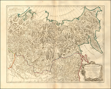
Fine example of Willem Barentsz's map of the Polar regions, drawn from his observations during his third voyage of 1596-97, engraved by Van Deutecum for Linschoten's Navigatio . . .
The Barentsz map of the polar regions is a major landmark in Arctic cartography, depicting the details of his third voyage to this region, made in 1596-7. After becoming stuck on the ice and being forced to winter in the Polar regions, Barentsz utilized his time to create an elaborate and highly decorative manuscript map depicting his observations. His map contains 34 illustrations of sea monsters, ships and whales and an island named "Polus Magnetis." The first edition of the map is extremely rare. Among other important firsts, the map is the first to depict Spitsbergen, shown as "Het Nieuwe Land" above Finmarchia.
Willem Barentsz was a Dutch map maker and explorer. His first major work was an atlas of the Mediterranean, which he co-published with Petrus Plancius. Barentsz believed that the North Polar regions included a northeastern passage to the Pacific and that the Polar regions consisted of open waters above Siberia, due to the fact that they would be exposed to the sun 24 hours per day. In the last decade of the 16th Century, Barentsz made 3 voyages to the North Polar regions. In June 1594, Barentsz led an expedition of 3 ships which sailed from Texel for the Kara Sea. On this voyage, the crew made the first ever encounter with a polar bear. Barentsz's first voyage reached the west coast of Novaya Zemlya. After coasting northward, the crew encountered large icebergs and were forced to turn back and return to Holland.
In 1595, Prince Maurice of Orange commissioned a second Barentsz led expedition, which included 6 ships and a cargo of goods which were intended for trade with China. The expedition made several noteworthy encounters with Samoyed "wilde men" and polar bears, but was forced to turn back when they encountered a frozen Kara Sea.
In 1596, the Town Council of Amsterdam sponsored a voyage of two ships, in hopes of claiming a reward offered by the Dutch States-General to first expedition which navigated the northeast passage. Barentsz voyage discovered Spitsbergen, before reaching Bear Island on July 1, 1596 and Novaya Zembla on July 17, 1596. Shortly thereafter, Barentsz's ship was stranded by ice and the 16 man crew was forced to winter on the ice. After making it through the winter, the crew set out in two small boats on June 13, with Barentsz dying about 7 days later. Seven weeks later, the remainder of the crew reached Kola and were rescued by a Russian Merchant ship. The crew made it back to Amsterdam in November 1597 and several crew members wrote accounts of the voyage. The wooden lodge where Barentsz's crew spent the winter was not revisited until 1871, when Norwegian seal hunter Elling Carlsen discovered the hut in 1871. In 1875, Captain Gunderson returned to the site and collected several artifacts, including 2 maps and a handwritten transalation of the Pet and Jackman voyages. In 1876, Charles L.W. Gardiner visited the site and collected many more artifacts and documents, including Barentsz's and Jacob van Heemskerck's notes on the settlement.
![(Riga, Latvia) Riga die Haupt Statt in Liefflandt von König Carln auss Schweden mit Krig Etlich mal angefochten. [Riga, the main city in Livonia, was repeatedly attacked by King Charles of Sweden with his army.]](https://storage.googleapis.com/raremaps/img/small/68157.jpg)
![[Map of the World on a Globular Projection Exhibiting Particularly the Nautical Researches of Capn. James Cook, F.R.S. with all the Recent Discoveries to the Present Time carefully Drawn by A. Arrowsmith . . . ]](https://storage.googleapis.com/raremaps/img/small/94140.jpg)
![[Early Photographic Facsimile in 24-Sheet of the Verrazano World Map]](https://storage.googleapis.com/raremaps/img/small/67041.jpg)