


|
||

|

|
|

|
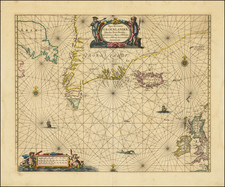
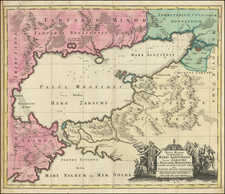
Fine Example of Willem Barentsz's Map of the Polar Regions
A landmark in Arctic cartography, the map is drawn from his observations during Barentsz’s third voyage (1596-7) and engraved by the skilled Baptista van Doetecum.
The map shows a sophisticated understanding of the Polar coasts of Europe as far east as Novaya Zemlya (often written as Nova Zembla and meaning "New World" in Russian), the furthest east that Barentsz reached. The mapping of the west coast of Novaya Zemlya is very comprehensive and features dozens of placenames. Barentsz and his men were forced to winter on the northeast of the island, which is marked on this map with a small hut, made of ships’ timbers, and the label 'Het Behouden Huys,' or the safe house.
This is the first map to depict Spitsbergen, shown as Het Nieuwe Land north of Scandinavia. Barentsz discovered this far northern archipelago in 1596.
The coasts of Asia, further to the east, are speculative, with unfinished shores in Tartary. Here, reindeer pull a sleigh. Beyond this area is northernmost Asia, with some familiar place names like Mongul. At the edge of Eurasia lies the apocryphal Strait of Anian, supposedly the gateway from the Arctic to the Pacific Ocean. On the other side of the strait is Bergi Regio.
In the northern part of the strait is a curious looking island. This is the Polus Magnetis, an island-like symbol meant to show the difference between the North Pole and the Magnetic North Pole. Navigators in this period well understood the effect of magnetic declination on their compasses and they had to accommodate for the variation when sailing.
In the west, Greenland and Iceland are well defined, along with the mythical island of Frisland (sometimes Friesland). To the south and west of Greenland are the straits and parts of Baffin Island recently discovered by Martin Frobisher and John Davis. Further north is the mythical Estotiland, which, like Frisland, originated from the apocryphal fourteenth-century Venetian voyage by the brothers Zeno.
One of the most notable features of the map are the many whales that dot the waters. Barentsz knew that his discoveries, especially Spitsbergen, would be a boon to the whaling industry. In addition, there are groups of seals, which were also hunted for their hides, meat, and fat. There is also a large ship near the Faroe Islands and several ships along the track of Barentsz’s voyage.
The voyages of Willem Barentsz
During the early 1590s, the leading merchants of the Dutch Republic became very interested in opening trade routes with East Asia. Yet, they were deeply concerned that the established route to Asia, by way of the Cape of Good Hope and the Indian Ocean, was under the control of the Portuguese, who were enemies of the Dutch. Moreover, the established route was very long, and it was thought that any navigable polar route to Asia would be more expeditious.
While exploring the Northwest Passage via the North American Arctic was considered, the failure of Martin Frobisher and John Davis's various attempts to find such a route in the 1570s and 1580s discouraged any efforts in this direction. In 1553-54, the English adventurers Sir Hugh Willoughby and Richard Chancellor attempted to find a Northeast Passage to Asia, over Siberia, and while their mission ultimately failed in this regard, their progress and the nature of their reports convinced many in Amsterdam that such a passage could quite plausibly be opened, given another attempt. This torch was to be carried by Willem Barentsz.
Willem Barentsz (c. 1550-1597) was a Dutch map maker and explorer and one of the great pioneers of Arctic exploration. His first major work was an atlas of the Mediterranean, which he co-published with Petrus Plancius. Barentsz believed that the polar regions consisted of open waters above Siberia, due to the fact that they would be exposed to the sun 24 hours per day.
In the last decade of the sixteenth century, Barentsz made three voyages to the North Polar regions. In June 1594, Barentsz led an expedition of three ships which sailed from Texel to the Kara Sea. On this voyage, the crew made the first ever encounter with a polar bear. Barentsz's first voyage reached the west coast of Novaya Zemlya. After coasting northward, the crew encountered large icebergs and were forced to turn back and return to Holland.
In 1595, Prince Maurice of Orange commissioned a second expedition led by Barentsz, which included six ships and a cargo of goods which were intended for trade with China. The expedition made several noteworthy encounters with Samoyed "wilde men" and polar bears but was forced to turn back when they encountered a frozen Kara Sea.
In 1596, the Town Council of Amsterdam sponsored another voyage of two ships. They hoped to claim a reward offered by the Dutch States-General to the first expedition that navigated the Northeast Passage. Barentsz’s third voyage discovered Spitsbergen, before reaching Bear Island on July 1, 1596, and Novaya Zembla on July 17, 1596. Shortly thereafter, Barentsz's ship was stranded by ice and the sixteen-man crew was forced to winter there. After the spring thaw, the crew set out in two small boats on June 13; Barentsz died roughly seven days later. Seven weeks on, the remainder of the crew reached Kola and were rescued by a Russian merchant ship. The crew made it back to Amsterdam in November 1597 and several crew members wrote accounts of the voyage.
The wooden lodge where Barentsz's crew spent the winter was not revisited until 1871, when it was discovered by the Norwegian seal hunter Elling Carlsen. In 1875, Captain Gunderson returned to the site and collected several artifacts, including two maps and a handwritten translation of the Pet and Jackman voyages. In 1876, Charles L.W. Gardiner visited the site and collected many more artifacts and documents, including Barentsz's and Jacob van Heemskerck's notes on the settlement.
Publication of the map and rarity
This map was originally published as a separately issued map; several surviving examples can be found bound into composite atlases of the period. The map was also included in some copies of Linschoten's Navigatio ac itinerarium... (Amsterdam, 1598). After travelling in Iberia, India, and Africa, Linschoten accompanied Barents on his first two voyages, so he had a vested personal and commercial interest in promoting his late friend's discoveries.
The map is a well-balanced masterpiece of Late Mannerist Style. This is testament to the fact that Linschoten commissioned Baptist van Deutecum, one of the finest engravers and artists in the Low Countries, to design and engrave the map.
While Barentz's attempts to find the Northeast Passage were ultimately not successful, his bravery and intellectual curiosity inspired future generations of polar explorers. This magnificent map serves as a foundation for all further Arctic exploration and mapping, especially in search of the Northeast Passage, making it one of the most important maps of its period. Barentsz's map is much prized by collectors.
![Descriptio totius Italiae [bound with:] Rerum Moscoviticarum commentarij ... quibus Russiae ac Metropolis eius Moscoviae descriptio, Chorographicae tabulae, Religionis indicatio, Modus excipiendi & tractandi oratores, Itineraria in Moscoviam duo, & alia quaedam continentur](https://storage.googleapis.com/raremaps/img/small/93228.jpg)