|
||

|

|
|

|
A fascinating and rarely offered railroad map with its accompanying 96 page report, Kansas and the Country Beyond, on the Line of the Union Pacific Railway, Eastern Division, from the Missouri to the Pacific Ocean, by Josiah Copley.
Although there seemed to be a little remainder from 1936 to 1966, thereafter offerings in the trade have been almost nonexistent." (Auction 21).
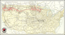
In addition to the railroad information, the map includes a key to identify the areas of the west that contain gold, silver, copper, quicksilver (mercury) and coal. This example is also important for its documentation of Indian Reservations, whose lands are shown in orange, but are not listed in the key. Regarding this map, Wheat says, "...Keeler's railroad map is full of factual information, but it is also full of hope." This map is very similar to Keeler's more common National Map of The Territory of The United States From The Mississippi River To The Pacific Ocean, also published in 1867.
William Keeler's map of the Western US is regarded as a landmark map in the mapping of the Western United States, providing the best detailed and comprehensive look at the Western Railroad System after the close of the Civil War. The map was widely distributed and its influence on the history of the Mapping of the Transmississippi West is profound. In the same year, Keeler's contributed a much rarer and slightly smaller portion of his National Map for this rare pamphlet issued by the Kansas Pacific Railroad.
In the spring of 1867 the President of the Kansas Pacific, invited a large group of prominent Americans, including many members of Congress, to travel by railroad from Philadelphia to Fort Harker in Kansas, 225 miles west of the Missouri River. Josiah Copley, one of the group invited to travel west, wrote a series of dispatches to the Pittsburgh Gazette reprinted at Philadelphia later in 1867 as Kansas and the Country Beyond.... Copley illustrated his book with this now extremely rare version of Keeler's map of which the book says "is probably the most accurate and reliable Railroad Map that has ever been offered to the public. It is a facsimile of the official map prepared from the most recent surveys and explorations under the authority of the Government at Washington, and was drawn and engraved by W. J. Keeler, Esq., of the Indian bureau, expressly for this work. The lines of both the great Pacific Railroads are laid down as nearly as possible as they are to be, and with equal fairness and fidelity. It was not deemed to be either honest or politic to insult the intelligence of the country by stretching a favorite line, like a ribbon, across the continent, and then attempting to ignore, as far as possible, all other roads that are not subsidiary to it. All that is essential to a full and fair understanding of the great question of routes from the Missouri to the Pacific is given."
The present map, as Wheat notes, is not the same as Keeler's National Map, but rather an amplification with focus on the railroads.
![[ Orange County ] Fire Cleveland - Trabuco District Fire Patrol Zone Map Effective August 1924.](https://storage.googleapis.com/raremaps/img/small/104665.jpg)