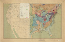
![[Separately Published Example!] Map of the United States of America. Designed to illustrate the Geological Memoir of Wm. Maclure Esq. By John Melish / Charles Alexandre Lesueur](https://storage.googleapis.com/raremaps/img/small/90048.jpg)


|
||

|

|
|

|
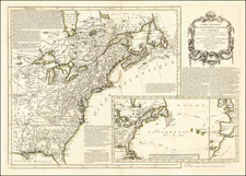
First edition of John Melish's map of the United States and the first map engraved by Henry Schenk Tanner, who would go on to produce some of the best American maps and atlases of the 19th Century.
According to Walter Ristow, this is Tanner's first map, which appeared in Melish's Travels in the United States of America, in the years 1806 & 1807, and 1809, 1810 & 1811 ... Illustrated by eight maps. . . (Thomas & George Palmer, agents for the author. 1812.). Ristow notes that Tanner's name is listed on the U.S. map in this first edition, but it is removed in the second edition, making it very easy to identify the states and Tanner's contribution. The map itself would have a fascinating life. After appearing in early Melish Travel guides, the map would be augmented with additional information and reissued over the next decade in several important American works, including William MacClure's Geographical Memoir. . . . published by the American Philosophical Society.
An interesting map of the United States, reflecting the early collaboration of two of America's most important map makers.
John Melish (1771-1822) was the most prominent American mapmaker of his generation, even though his cartographic career lasted only a decade. Melish was born in Scotland; he moved to the West Indies in 1798 and then to the United States in 1806. By 1811, he had settled in Philadelphia and published Travels through the United States of America, in the years 1806 & 1807, and 1809, 1810, & 1811, which was richly illustrated with maps.
Melish created several regional maps of the highest quality, as well as the Military & Topographical Atlas of the United States (Philadelphia, 1813, expanded 1815). The latter work is widely considered to be the finest cartographic publication to come out of the War of 1812.
By far his best-known work is his monumental map of the United States of 1816, Map of the United States with the contiguous British and Spanish Possessions. He began working on the map in 1815 and sent it to Thomas Jefferson for comment in 1816. Jefferson enthusiastically reviewed the map and returned it with his edits. Jefferson later hung an example of the map in the Entrance Hall of Monticello and sent it to associates in Europe.
Melish’s finished product was the first map of the United States to extend to the Pacific Ocean. After its publication in 1816, Melish ensured the map was as up-to-date as possible; it was reissued in 25 known states published between 1816 and 1823. The map captured the then rapidly changing geography of the United States, as well as various boundary disputes, treaties, and expansion.