|
||

|

|
|

|
Stock# 64522
Description
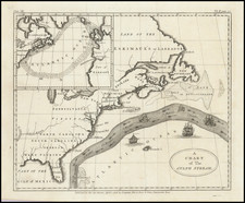
Nice example of the first edition of this scarce separately issued broadside Revolutionary War Map of the British Colonies.
The map includes a remarkable amount of historical, topographical and military notes and details concerning the British Colonies and neighboring regions, along with a large inset map of the Pacific, showing the various French trading routes to the new world from Brest, Nantes, Rochefort, Lisbon and Cadiz.
Excellent Indian & Colonial detail, especially in the Ohio Valley and western Virginia, where a number of early English forts and settlements are noted.
There are also some dates regarding conflicts going back to the French & Indian War in the Ohio Valley.
Reference
Sellers and Van Ee 155.
![[ Early United States ] Etats Unis De L'Amerique](https://storage.googleapis.com/raremaps/img/small/98746.jpg)