|
||

|

|
|

|
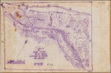
Eugene Duflot De Mofras' map of San Francisco is one of the earliest printed maps of the harbor and one of the earliest obtainable regional maps of the region.
The map is remarkably detailed and includes soundings, topographical details, notes on the entrance and approaches, rivers, roads, towns, missions and a host of other details. The map is derived from William Beechey's rare chart of San Francisco Bay, first published in 1833, based upon Beechey's surveys in 1827-1828, with corrections based upon Duflot Du Mofras's observations. Duflot de Mofras' Exploration Du Territoire De L'Oregon, Des Californies Et De La Mer Vermeille . . . is generally considered to be the best book on California prior to the American occupation. The book included an atlas of maps of the Pacific Coast. Wheat calls the large map a landmark... It made these western regions known in European official circles...his highly original map has much to commend it. The atlas volume contains, in addition to the large map, plans of ports from Acapulco to the Aleutians, including San Pedro, San Diego, Santa Barbara, Monterey, San Francisco, and the mouth of the Columbia. Duflot de Mofras sailed from Mazatlan in April 1841, touching first on San Pedro, where the observations for this original work were made. A nice example with wide margins.
An essential map of California collectors.
Eugene Duflot de Mofras was a traveler, naturalist, diplomat, and spy. In 1839, du Mofras was appointed attaché to the French delegation to the Mexican government. While there, he was tasked with visiting the northern areas of Mexico; he was sent both as an official visitor but also as a veritable spy, gathering intelligence as to likely places to establish French trading posts. In 1844 he published an account of his travels, complete with an influential map of western North America.