The item illustrated and described below is sold, but we
have another example in stock. To view the example which
is currently being offered for sale, click the
"View Details" button below.


|
||

|

|
|

|
Stock# 15031
Description
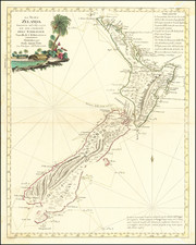
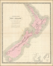
Excellent large map of New Zealand, which includes early notes on the first sighting of New Zealand by Tasman in 1642, Cook's discoveries, the Royal Proclamation of independence in 1841, etc. Whaling stations around the islands are noted. Inset maps of Port Nicholson, Port Cooper and Port Levy. One of the largest maps of New Zealand to appear in a commercial atlas in the 19th Century. Decorative Piano Key border. Fine example, on thick heavy paper. From Johnston's scarce National Atlas.