|
||

|

|
|

|
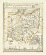
This detailed 1892 map of Ohio by G.W. & C.B. Colton & Co. showcases the state's counties, townships, and railroads. The map is intricately bordered with floral designs and highlights the development of the state's transportation network at the time. A notable feature is the inset of the state capitol building located in Columbus. The population table on the right-hand side provides valuable demographic information from the period. The map is colored in a vibrant palette.
G. W. & C. B. Colton was a prominent family firm of mapmakers who were leaders in the American map trade in the nineteenth century. The business was founded by Joseph Hutchins Colton (1800-1893) who bought copyrights to existing maps and oversaw their production. By the 1850s, their output had expanded to include original maps, guidebooks, atlases, and railroad maps. Joseph was succeeded by his sons, George Woolworth (1827-1901) and Charles B. Colton (1831-1916). The firm was renamed G. W. & C. B. Colton as a result. George is thought responsible for their best-known work, the General Atlas, originally published under that title in 1857. In 1898, the brothers merged their business and the firm became Colton, Ohman, & Co., which operated until 1901, when August R. Ohman took on the business alone and dropped the Colton name.
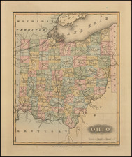
![The State of Ohio with part of Upper Canada, &c. [and Part of Michigan Territory within Ohio]](https://storage.googleapis.com/raremaps/img/small/104238.jpg)