|
||

|

|
|

|
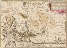
Fort de la Knocque / Fort Konkke During The War of Spanish Succession
This rare map of Fort Knokke presented to the States General of the United Provinces in 1712, depicts the strategic fortification located near Nieuwpoort, Flanders. The fort was crucial for controlling the region and safeguarding against enemy advances during the War of the Spanish Succession.
The site of Fort Knokke, located at the confluence of the Yser River and the Ypres Canal near Lo-Reninge, was a point of strategic importance.
The map showcases the fort's intricate star-shaped design, typical of military architecture in the early 18th century. The detailed drawing highlights the fort's bastions, ravelins, and defensive walls, which were designed to repel sieges and direct assaults. Surrounding the fort, the map illustrates the surrounding flooded areas ("inondé pendant tout l'hiver"), indicating the use of deliberate inundation as a defensive measure to hinder enemy movement.
Key Features
- The Star Fort Design: The fort's star-shaped layout is a prime example of the trace italienne (Italian style) fortifications, which emerged during the Renaissance and were widely adopted in Europe for their defensive advantages.
- Inundation Strategy: The surrounding areas marked as "inondé pendant tout l'hiver" (flooded throughout the winter) demonstrate the deliberate use of water as a defensive tactic to create impassable barriers for enemy forces.
- Governor's Garden: The mention of the Governor's Garden, where Mr. la Rue prepared for an expedition, indicates the fort's role as a command center for military operations.
- Dike Construction: The dike's role in preventing Nieuwpoort from draining the fort highlights the constant engineering efforts to maintain and protect strategic positions.
Fort Knokke, also known as Fort de Cnocke, Fort de la Knocque, or Fort de Knocke, served as a significant military fortification in western Flanders from the 1580s until its demolition in the 1780s. It was initially constructed by the Spanish Empire between 1584 and 1591 during the Eighty Years' War, under the command of the Duke of Parma, Alexander Farnese, to defend against Dutch rebels. The fort's strategic importance was recognized during the Franco-Spanish War, leading to its reconstruction in 1649.
In 1668, the fort came under French control through the Treaty of Aix-la-Chapelle. King Louis XIV tasked the renowned military engineer Sébastien Le Prestre de Vauban with redesigning and enhancing its defenses in 1678, transforming it into a formidable stronghold. During the Nine Years' War, Fort de la Knocque was attacked by the Grand Alliance in 1695 but successfully defended by the French garrison.
In 1712, amid the War of the Spanish Succession, the fort was captured by a clever ruse orchestrated by Prince Eugene of Savoy. He employed a partisan named La Rue, who, with the assistance of troops from Ostend, infiltrated and seized the fort. This event highlighted the vulnerability of French defenses and was a prelude to the Barrier Treaty of 1713, where control of strategic fortifications in the Austrian Netherlands, including Fort Knokke, was transferred to the Dutch Republic to prevent future French invasions.
During the War of the Austrian Succession, the fort was besieged and captured by the French in 1744 after a prolonged siege. By the late 18th century, the fort's military relevance diminished, and in 1781, Emperor Joseph II of Habsburg Austria ordered its demolition.

![[Spa, Belgium]. Plan de Spa, Situe a Sept Lieves de Liege, au Midi, Si Renomme Par Ses Eaux Minerales, dans le quel Sont Designes les Princiapaux Edifices, les Maisons servant de Logement aux Etrangers et les Promenades Publiques](https://storage.googleapis.com/raremaps/img/small/61966.jpg)