|
||

|

|
|

|
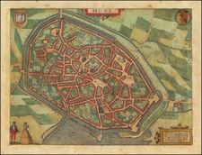
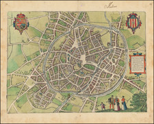
Bruxella, Urbs Aulicorum Frequentia, Fontium Copia, Magnificentia Principalis Aulae... is a detailed cartographic representation of Brussels circa 1567, produced by the notable cartographic team of Georg Braun & Frans Hogenberg.
Georg Braun's commentary, provided on the verso, complements this visual depiction by illuminating the social and architectural elements of the city. The royal palace, prominently situated on a hill, is noted as a significant embellishment to the cityscape and a site of important deliberations. The artificial waterway is also highlighted, attesting to the considerable efforts in enhancing the city's infrastructure for the benefit of both locals and visitors.
The layout of the city is also evident from the map's bird's eye perspective, providing an insight into the urban planning of the time. The city wall enclosing vast tracts of land, the expansive streets, and the network of canals enabled by the navigable River Senne are clearly marked, providing a vivid impression of the city's physical landscape.
The map also signals the city's cultural prominence, suggesting a thriving community of artists, craftsmen, manuscript illuminators, sculptors, and goldsmiths. It notes the residence and work of prominent artist Pieter Breughel the Elder, further accentuating Brussels' status as a cultural hub during this period.
The underlying sources of this engraving, including a plan from Guicciardini (1567) and potentially a sketch by Jacob van Deventer (c. 1550), speak to the methodical compilation and synthesis of data, reinforcing its reliability as a historical and geographical resource. In essence, this map, with its rich detail and broad coverage, serves as a valuable reference for understanding Brussels in the late 16th century.
Georg Braun (1541-1622) was born and died in Cologne. His primary vocation was as Catholic cleric; he spent thirty-seven years as canon and dean at the church St. Maria ad Gradus, in Cologne. Braun was the chief editor of the Civitates orbis terrarum, the greatest book of town views ever published. His job entailed hiring artists, acquiring source material for the maps and views, and writing the text. In this role, he was assisted by Abraham Ortelius. Braun lived into his 80s, and he was the only member of the original team to witness the publication of the sixth volume in 1617.
Frans Hogenberg (ca. 1540-ca. 1590) was a Flemish and German engraver and mapmaker who also painted. He was born in Mechelen, south of Antwerp, the son of wood engraver and etcher Nicolas Hogenberg. Together with his father, brother (Remigius), uncle, and cousins, Frans was one member of a prominent artistic family in the Netherlands.
During the 1550s, Frans worked in Antwerp with the famous mapmaker Abraham Ortelius. There, he engraved the maps for Ortelius’ groundbreaking first atlas, published in Antwerp in 1570, along with Johannes van Deotecum and Ambrosius and Ferdinand Arsenius. It is suspected he engraved the title page as well. Later, Ortelius supported Hogenberg with information for a different project, the Civitates orbis terrarium (edited by Georg Braun, engraved by Hogenberg, published in six volumes, Cologne, 1572-1617). Hogenberg engraved the majority of the work’s 546 prospects and views.
It is possible that Frans spent some time in England while fleeing from religious persecution, but he was living and working in Cologne by 1580. That is the city where he died around 1590. In addition to his maps, he is known for his historical allegories and portraits. His brother, Remigius, also went on to some fame as an engraver, and he died around the same time as his brother.
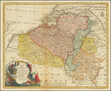
![[ Belgium ]. Les Provinces des Pays-Bas Catholiques ou a Most Exact Map of Flanders or ye Austrian Netherlands &c. . . .](https://storage.googleapis.com/raremaps/img/small/102631.jpg)