


|
||

|

|
|

|
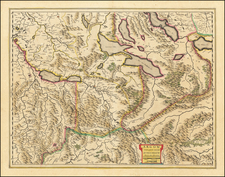
This map presents the Swiss Confederation as it existed around the early 18th century. Published in the early 18th Century, this map captures the intricate political and geographic landscape of Switzerland, highlighting its thirteen cantons along with their federated and subject territories.
The map is a finely engraved work, showcasing the territorial divisions and alliances that defined Switzerland at the time. The title cartouche, situated prominently in the upper-left corner, is an elaborate composition featuring allegorical figures and heraldic symbols. The coat of arms of the thirteen cantons is centrally displayed, flanked by cherubs and decorative elements, indicating the unity and strength of the Helvetic Republic.
During this period, Switzerland was a confederation of semi-autonomous cantons with a complex network of alliances and dependencies. The map reflects the geopolitical structure established through various treaties and agreements that shaped the Swiss Confederation's boundaries and internal governance. The map's detailed representation of the cantonal coats of arms underscores the significance of heraldry in asserting regional identities and loyalties.
Johann Baptist Homann (1663-1724) was a mapmaker who founded the famous Homann Heirs publishing company. He lived his entire life in Bavaria, particularly in Nuremberg. Initially, Johann trained to become a priest before converting to Protestantism and working as a notary.
In 1702, Johann founded a publishing house that specialized in engravings. The firm flourished, becoming the leading map publisher in Germany and an important entity in the European map market. In 1715, Johann was named Imperial Geographer to the Holy Roman Empire by Charles VI and made a member of the Prussian Academy of Sciences. Most importantly for his business, his reputation and contacts gained him imperial printing privileges which protected his publications and recommended him to customers. Johann is best known for this Grosser Atlas ueber die ganze Welt, or the Grand Atlas of the World, published in 1716.
After Johann died in 1724, the business passed to his son, Christoph (1703-1730). Upon Christoph’s early death, the company passed to subsequent heirs, with the name of the company changing to Homann Erben, or Homann Heirs. The firm continued in business until 1848.
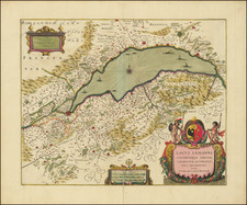
![[ St. Gallen Region / Bodenzee ] Die zwey erste Zugwandte Orte der Eidgnosschaft nemlich Der Furstliche Abt Von St. Gallen und die Stadt St. Gallen sampt dem Toggenburg und denen angraenzenden Orten Appenzell, Thurgeu und Rheinthal . . . 1768](https://storage.googleapis.com/raremaps/img/small/103390.jpg)