|
||

|

|
|

|
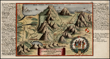
The Two Foremost Allied Places of the Swiss Confederation, namely the Princely Abbey of St. Gallen and the City of St. Gallen, together with Toggenburg and the Adjacent Areas of Appenzell, Thurgau, and the Rhine Valley
Striking example of Gabriel Walser's regional map of "the two foremost allied places of the Swiss Confederation, delineating the principality of the Abbey of St. Gall, the city of St. Gallen, Toggenburg, and the adjoining locales of Appenzell, Thurgau, and the Rhine Valley, to the south of the Bodenzee.
The region, known for its pastoral landscapes and burgeoning textile industry, shows St. Gallen, both the city and its surrounding principality governed by the Prince-Abbot, as an ecclesiastical state that wielded considerable influence in Northeastern Switzerland. Notable communities within this region, such as the autonomous region of Appenzell—divided into Inner Rhodes and Outer Rhodes—and the agricultural canton of Thurgau are meticulously marked, emphasizing their political and economic significance.
The Toggenburg area, with its verdant valleys and the jagged peaks of the Churfirsten range, is rendered in detail, capturing the topographical diversity that has long defined the Swiss landscape. The uppermost portion of the Rhine River Valley is depicted as a vital corridor, with the Rhine River itself serving as a lifeline for commerce and communication, an artery that has historically connected these territories with the wider European tapestry.
During the 18th century, these regions were at the nexus of religious, cultural, and political developments. St. Gallen's abbey was an epicenter of the baroque splendor and intellectual pursuit, with its library renowned as one of the richest and oldest in the world, fostering enlightenment thought. Meanwhile, the industrious city of St. Gallen prospered from the textile trade, enhancing its stature amongst Swiss communities.
Johann Baptist Homann (1663-1724) was a mapmaker who founded the famous Homann Heirs publishing company. He lived his entire life in Bavaria, particularly in Nuremberg. Initially, Johann trained to become a priest before converting to Protestantism and working as a notary.
In 1702, Johann founded a publishing house that specialized in engravings. The firm flourished, becoming the leading map publisher in Germany and an important entity in the European map market. In 1715, Johann was named Imperial Geographer to the Holy Roman Empire by Charles VI and made a member of the Prussian Academy of Sciences. Most importantly for his business, his reputation and contacts gained him imperial printing privileges which protected his publications and recommended him to customers. Johann is best known for this Grosser Atlas ueber die ganze Welt, or the Grand Atlas of the World, published in 1716.
After Johann died in 1724, the business passed to his son, Christoph (1703-1730). Upon Christoph’s early death, the company passed to subsequent heirs, with the name of the company changing to Homann Erben, or Homann Heirs. The firm continued in business until 1848.
Gabriel Walser he began his theology studies in Basel in 1712, and, after study visits in Marburg, Tübingen, Jena, and Halle, he completed his examination there in 1717. He became a member of the Appenzell Synod. In 1718, he married Maria Elisabeth Zollikofer, who hailed from a noble St. Gallen family and was the daughter of Ruprecht Zollikofer. In 1721, he was elected as the pastor of Speicher, where he served from 1721 to 1745. In the land trade, he took the side of the defeated Lindens and was thus fined in 1732. In 1745, he took up the pastoral position in Berneck, which he held until his death.
In addition to his duties as a pastor, Gabriel Walser wrote the "Old and New Appenzeller Writing Calendar" for the years 1738 to 1745, a collection with easy-to-understand scientific, historical, and narrative content.
His main work was the "Neue Appenzeller-Chronick or Description of the Canton of Appenzell of the Inner and Outer Rooden", self-published in 1740. This history of the Canton since Roman times also included geographic descriptions, including a map of Appenzell. It contained an appendix with various documents from the years 1378 to 1667 and an official directory. Walser's chronicle is considered an extension and continuation of the Appenzell Chronicle of the pastor Bartholomäus Bischofberger from Trogen, which goes up to the year 1682. The more valuable, regional part of the chronicle is based on his observations. The historical part connects to Bartholomäus Bischofberger's work and supplements it up to 1732. His continuation for the years 1732 to 1772 was only published in 1829.
For the Augsburg publisher Matthaeus Seutter, Walser created maps of the cantons Lucerne, Uri, Schwyz, Glarus, and Appenzell as well as Graubünden, after numerous trips through eastern and central Switzerland. For the "Atlas Novus Reipublicae Helveticae", published in Nuremberg in 1769, he created,15 maps covering 18 cantons covering the 18 cantons of the Old Confederacy (excluding Schaffhausen) and the territories of St. Gallen, Graubünden, and Wallis, based on maps by Johann Jakob Scheuchzer, Hans Konrad Gyger, and others,from 1763 to 1768. Walser did not carry out any surveys for this. However, his maps represent a slight qualitative improvement compared to Scheuchzer's maps. In 1770, Walser's "Swiss Geography with the Sights in the Alps and High Mountains" was published in Zurich. This is an explanation of the atlas.
![[St. Gallen Canton] Le Pais de Toggenbourg, desine par Monsr. Jean Jacques Scheurchzer . . .](https://storage.googleapis.com/raremaps/img/small/80197.jpg)
![[ Switzerland ]. Suisse](https://storage.googleapis.com/raremaps/img/small/102837.jpg)