|
||

|

|
|

|
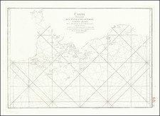
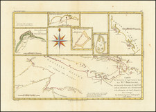
This map shows the discoveries made by the French frigates La Boussole and L'Astrolabe during their 1787 expedition from Manila to Kamchatka. The map details the eastern coasts of Asia, including parts of China, Korea, Japan, and the Philippines, as well as various islands in the surrounding seas. The precise charting highlights the explorative endeavors of the French during this period, contributing to the broader geographical knowledge of East Asia.
Created under the direction of Jean-François de Galaup, comte de La Pérouse, this map represents the French explorations in East Asia during the late 18th century. In 1787, the frigates La Boussole and L'Astrolabe embarked on a significant voyage to chart the uncharted waters of the China and Tartary Seas. This expedition aimed to enhance the geographical and navigational knowledge of the region, crucial for trade and military strategy, and French aspirations to control and colonization of the Pacific.
![ПОЛИТИЧЕСКАЯ КАРТА Азии [Political Map of Asia]](https://storage.googleapis.com/raremaps/img/small/90255.jpg)